- 7738 views
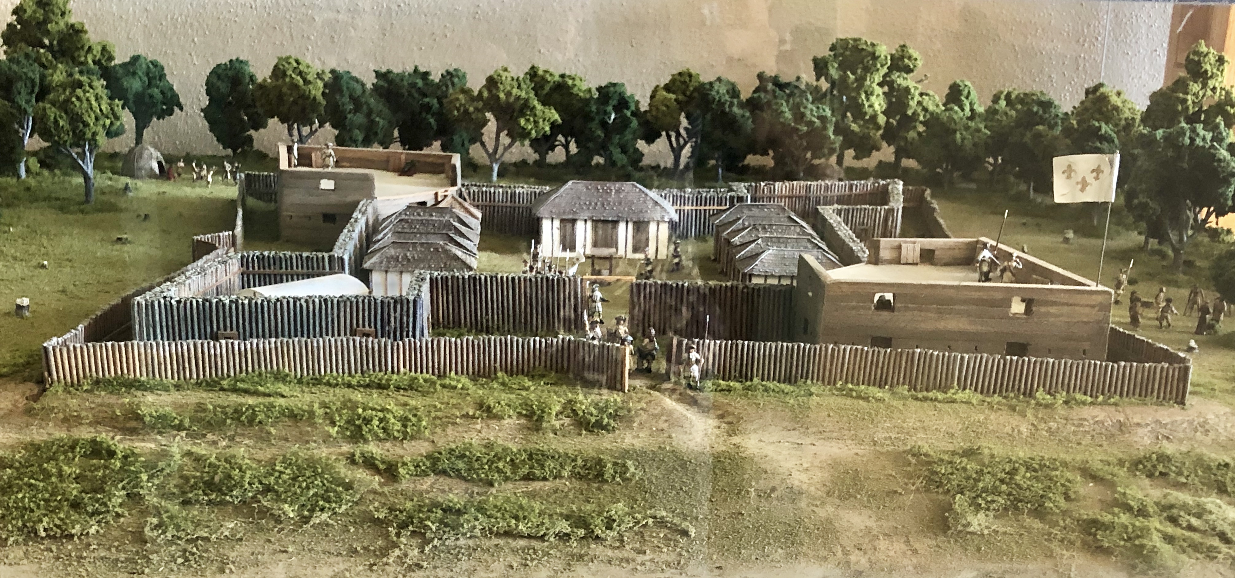
Fort Maurepas Scale Model
[created by Marc Poole, Art Director at MGCCC-Gautier, Mississippi for the Mary C. O'Keefe Cultural Center-Ocean Springs, Mississippi]
FORT MAUREPAS [1699-2009]: yesterday, today, and tomorrow
For those who have not cruised Front Beach lately, it might be interesting to them to know that their City government is expending much energy and money to improve and revitalize the site of the former, unfinished Fort Maurepas replica and environs situated between Washington Avenue and Jackson Avenue. This new venue is called Fort Maurepas Park, I prefer ‘Parc de Maurepas’, but who cares? It will essentially replace the footprint of the 1981 fort replica, but outside of this area there will be a pavilion, bronze statue of Pierre LeMoyne, Sieur d’ Iberville (1661-1706), a children’s play area, and splash park, as well as a paved parking area. On the south side of Front Beach Drive fronting the new park is the new community pier, the first phase of this ambitious project.
Land title
Eric Clark, Mississippi Secretary of State, revealed in a letter to Mayor Connie Moran on July 24, 2006, that the preliminary plans of the City of Ocean Springs to create a Fort Maurepas Park on the site of the Katrina, damaged-destroyed, Fort Maurepas replica met with his approval and satisfied the requirement that Ocean Springs maintain the State donated property as an historic site. To quote from Mr. Clark: "The State conveyed the property to the City of Ocean Springs in 1991, and the deed requires the City to maintain the property as an official historic site. I have concluded that the plan described above honors that requirement and I am happy to give my approval. I wish you well with this project, and with your efforts to rebuild and improve your beautiful city."(The Ocean Springs Record, August 17, 2006, p. A10)
With the State of Mississippi apparently not financially capable of committing funds to complete the 1981 Fort Maurepas replica, it was felt that if the City of Ocean Springs got title to the property something might be done to accomplish this goal. By February 1991, under the leadership of District 113 Representative, Alvin Endt, the House voted to transfer the title to the City of Ocean Springs. After Senate approval and Governor Ray Mabus's signature, Mayor Kevin Alves on April 25, 1991, received the quitclaim deed to the two tracts containing the Fort Maurepas Reconstruction from the State of Mississippi by the Department of Archives and History and Department of Wildlife, Fisheries, and Parks. The State of Mississippi retained all mineral rights and stipulated that the city maintain the fort as a historic site and include in its annual budget sufficient funds to maintain the structure.(Jackson County Deed Book 975, pp. 113-117).
A ceremony was held at the Fort Maurepas replica on July 21, 1991 where Mayor Kevin Alves accepted the title to Fort Maurepas from Elbert R. Hilliard, representing the Mississippi Department of Archives and History. U.S. Representative Gene Taylor addressed the group and said that the fort was "worthwhile to the preservation of our heritage", and pledged his support on seeing the replica completed. (The Ocean Springs Record, July 25, 1991, p. 1)
On August 20, 1991, Ross Dodds, chairman of the Environmental Concerns Committee of the Greater Ocean Springs Chamber of Commerce, proposed to the City of Ocean Springs that the marsh, wetlands, contiguous upland and wooded habitats which were adjacent to the Fort Maurepas replica be declared an "inner city" nature preserve-the Fort Maurepas Nature Preserve. The City Board accepted the proposal, which additionally provided for the protection, management, and development of a natural history program for the area. Discouragement of activities which might degrade the aesthetics, biological, scientific, or educational value of the area surrounding Fort Maurepas was another goal.(Minutes of the City of Ocean Springs, Mississippi (August 20, 1991), pp. 582-583).
Fort Maurepas Society
On June 10, 1992, an organizational meeting was held at the Ocean Springs City Hall to create the Fort Maurepas Society. Mike Williams, then Alderman representing Ward II, was instrumental in the group’s formation, whose salient goals were was to outfit, maintain, and complete the construction of the Fort Maurepas replica. Ray L. Bellande was elected the first Commandant. Under his leadership and with the desire and intensity of Gloria Smith Moran (1924-1999) and the able assistance of Dr. H. Bradley Heitzman, Harold Rogers, Mary Ross Terry, Anne and Bill Stietenroth, and Dr. Val Husley of Biloxi the Fort Maurepas Society commenced its first reenactment of French Colonial history and culture in early October 1993. The Fort Maurepas replica became the site of annual reenactments for about ten years with animators coming to Ocean Springs from the Fort Toulouse replica at the Fort Toulouse-Jackson Park near Wetumpka, Alabama; Fort de Chartres at Prairie du Rocher, Illinois; and Fort St. Jean-Baptiste in Natchitoches, Louisiana. In February 1999, to celebrate the 300th anniversary of the French Settlement on the Mississippi Gulf Coast, the Ouisconsin and Old Northwest Company animators camped at Fort Maurepas and participated with the Fort Maurepas Society in the Landing of Iberville at Biloxi on February 9th.
Dr. James ‘Pat’ Smith, USM-Long Beach history professor and thespian, was an exciting and informative participant in many of the Fort Maurepas replica reenactments and local celebrations. His portrayal of Iberville relating to his audience the life and times of Iberville, as a soldier and sailor for France against the English at Hudson Bay, James Bay, and Newfoundland in Canada to his arrival at Ship Island on the Mexican Gulf in February 1699, was very, very special.
Ground breaking
Ground was broken for Fort Maurepas Park on August 29, 2006 at the Front Beach site. Mayor Connie Moran opened the session with a welcoming statement to the small audience, which consisted primarily of local dignitaries and neighbors. She was followed by Ray L. Bellande, local historian, who gave a brief history of the old Hansell-Edwards-Bland property on which the 1981 Fort Maurepas replica had stood until Hurricane Katrina's wrath erased it August 29, 2005. Ken P' Pool from the Mississippi Department of Archives and History in Jackson, Mississippi closed the speech making with a review of the French Colonial history of the area with emphasis on Ft. Maurepas' importance to the French effort in securing and maintain the 1682 claim by Robert Cavelier, Sieur de La Salle (1643-1687). La Salle had left Canada and reconnoitered the Mississippi River from Illinois locating its deltaic mouth in April 1682. He claimed for France the vast area between the Rocky Mountains and the Alleghenies drained by the Mississippi and all of its tributaries. We know this territory as Louisiana, i.e. belonging to Louis, King Louis XIV. After P’ Pool’s remarks those invited dignitaries shoveled dirt to signify the commencement of the $1.3 million dollar project. Practically the entire cost of the Fort Maurepas Park development will be derived from FEMA funds, the Katrina Benefit Fund owned by the City of Ocean Springs, and the Department of Natural Resources Tidelands Fund, and individual public donations, thus placing no additional burden on taxpayers.(The Ocean Springs Record, August 31, 2006, p. A1)
Chester M. McPhearson Jr. pier
An integral part of the Fort Maurepas Parks master plan, the Mayor Chester M. McPhearson Jr. Community Pier, a concrete fishing and recreational venue, has been completed and has been enjoyed by many relishing the lure of the outdoors and its associated pleasures since March 2009.
Bids for the Maurepas Park pier were opened in July 2008 and the contract was let to construct a new, 650-foot pier with concrete pilings, lighting, a pavilion mid-way between the foot of pier and the T-head area at the head of the wharf. An area to clean fish which included running water was included in the design package. By mid-October 2008, the $722,000 water front structure was under construction with piles being set and a projected January 2009 completion date. The Department of Marine Resources will build an oyster reef at the termination of the pier to enhance fishing and rework the old reef off of the Katrina destroyed and abandoned Martin Avenue Community Pier to the west.(The Ocean Springs Record, July 10, 2008, p. A1)
The pier was completed in February 2009 by Brown and Mitchell Engineering of Gulfport. It was dedicated on March 21, 2009 and named in memory of Chester M. McPhearson Jr., who served the City as its Mayor from 1981 to 1989 and Ward IV Alderman from 1953-1961.(The Ocean Springs Record, March 19, 2009, p. 4) .
Chester Marvin McPhearson Jr. (1924-2006) came to Ocean Springs in 1946. He had recently been discharged with the rank of sergeant from the U.S. Army, following active duty service in the European theater during World War II. At Ocean Springs, Chester joined the M & M Supply Company, a general merchandising business on Washington Avenue, owned and operated by his father and brother, William M. McPhearson (1913-1963). Their motto was ‘Everything but Groceries”.(The Gulf Coast Times, April 1, 1949, p. 10 and The Ocean Springs Record, June 5, 1969, p. 9)
Chester had been born the son of Chester M. McPhearson Sr. (1883-1969), a native of Frost Bridge, Mississippi, and Willie Mae McPhearson (1888-1968) at Heidelberg, Jasper County, Mississippi on October 1, 1924. He was reared at Heidelberg and Meridian where he completed his high school education. In 1944, Chester M. McPhearson Sr. relocated to Ocean Springs. At Heidelberg, he had owned a business and was Mayor of the small community.(The Ocean Springs Record, June 5, 1969, p. 9)
Chester M. McPhearson Jr. met Mary Jane McCormick (1925-1990), a native of Bastrop, Louisiana, at Biloxi. She was reared at Biloxi. They were married on May 9, 1948. From this marriage were born: Mary Louise M. Cheek (b. 1954), Linda Joyce M. Walker (b. 1957), and John Richard McPhearson (b. 1961).
In November 1952, Mr. McPherson was nominated by Governor Hugh White and appointed by James Henderson, Director of Rent Stabilization, to the Biloxi-Pascagoula Rent Advisory Board. Chester M. McPhearson Jr. began his nascent political career in 1953 when he was elected alderman to represent the people of Ward 4. He served in this capacity until 1961. (The Gulf Coast Times, November 6, 1952, p. 1)
In February 1957, Chester was named manager of Crestlawn Cemetery. In the interim, he founded McPhearson's Mens Wear also in 1957 after the M & M Supply Company was sold. He was elected Mayor of Ocean Springs in 1981, on the Democratic ticket, and served two terms retiring from office in 1989. In 1981, Mayor McPhearson refused a pay raise. In 1982, the Board of Alderman approved that the salary of the Mayor be set at $24,000 from $17,796. Even at this pay scale, McPhearson made less than the City Engineer and only $2000 more per year than the highest paid city department head. While in office, He defeated Republican Steve Davis in the 1985 mayoral election. Mayor McPhearson tenets for the mayor's office were that the mayor should conduct the city's business in a fair and dignified manner and bring good business management with a sound fiscal policy to the position.(The Ocean Springs News, February 7, 1957, p. 4 and The Ocean Springs Record, August 19, 1982, p. 1)
In retirement, Chester M. McPhearson resided at 513 Rayburn Avenue in Ocean Springs. He acquired this home in February 1951, from Colonel G.R. Johnson. The McPhearson moved here from an apartment let to them by Mrs. Hugh Saxon on Jackson Avenue. Mayor McPhearson expired on August 3, 2006. His corporal remains were interred in the Evergreen Cemetery next to his spouse who had died in December 1990.(The Gulf Coast Times, February 22, 1951 and The Sun Herald, December 4, 1990, p. C2, and The Ocean Springs Record, August 10, 2006, p. A1)
Post-Katrina
In the fall of 2005, the remains and debris of the battered and inundated Fort Maurepas replica were removed as well as the flotsam and jetsam delivered by Hurricane Katrina in late August 2005. The large, bastion timbers were saved by the OS Public Works Department, who under the leadership of Andre’ Kaufman, have kept our City immaculate in recent years. Mayor Connie M. Moran called for a public meeting at the Ocean Springs Community Center on the eve of April 27, 2006 to discuss the future of the site. Frank Burandt of Greg Cantrell Inc., landscape architects, of Kenner, Louisiana presented his organizations design for the site. Mayor Moran said of the Fort Maurepas replica: "It was very user unfriendly and it was vandalized constantly, despite the installation of lighting and security cameras. We want this [new park] to be a place everyone can enjoy."(The Sun Herald, April 24, 2006, p. A3)
Fort Maurepas Park plan
In mid-June 2006, about one hundred residents of Ocean Springs Ward II, in which the Fort Maurepas replica had sat for almost twenty-five years, overwhelmingly approved the preliminary plan of Frank Burandt, landscape architect, for Fort Maurepas Park to be located on Front Beach Drive between Washington and Jackson Avenues. Fort Maurepas Park will feature a Great Lawn outlined by a low brick wall, which in plan view replicates a Marshall Vauban (1633-1707) fortification, similar to that erected by Iberville's men in April 1699. Marshall Vauban served Louis XIV (1638-1715) of France as a military engineer. The Great Lawn will be bisected by a brick walkway featuring enamel replicas of the many flags that have flown over the Mississippi Gulf Coast from the French Colonial period to present day. A circular enamel plaque with the date ‘1699’ and three fleur-de-lys will rest in the center of the brick path and will be flanked by the flags. There will be an outdoor stage on the north side of the Great Lawn and picnic areas in the southeast and southwest corners of this large green space.
The southeast side of the Great Lawn will be graced with statuary and historical markers commemorating the five centuries of local history. Other amenities of the Fort Maurepas Park will be a two-story pavilion with toilets, a playground for children, picnic tables, and a boardwalk on the southwest perimeter of the Fort Maurepas Nature Preserve.(The Ocean Springs Record, June 29, 2006, p. A1)
Project in limbo?
In mid-October 2006, the Board of Aldermen were informed by Adrienne Howell, City Clerk, that the anticipated $629,000 FEMA money intended for Fort Maurepas Park could be used ONLY to replace what was on the site, i.e. the 1981 Fort Maurepas replica. The Board believed that the FEMA grant was for the new park and voted not to spend any more money on the park project until it could be ascertained with certainty that funding was secure for the $1.3 million dollar project. Mayor Moran aspired that FEMA would accept the Fort Maurepas Park proposal as a qualified replacement for the destroyed Fort Maurepas replica.(The Ocean Springs Record, October 12, 2006, p. A1)
In January 2007, Mayor Moran related that an announcement of the historical site assessment of the Fort Maurepas Park property would soon be released. This investigation was performed by contractors hired by the Department of Homeland Security for FEMA to ascertain in particular that no Native American artifacts on the proposed park site. By mid-January, the State Historical Preservation Office confirmed that an archeological survey of the park site, which included soil borings found nothing adverse to prevent the construction of Fort Maurepas Park. The future of the project rested with financial assistance from FEMA, which was expected to pay 75 per cent of the estimated $1.3 million cost. A grant from the Department of Marine Resources [DMR] for $297,000 was given for parking, sidewalks, and for boardwalks to access the Fort Mauepas Nature Preserve. A private donation of $100,000 has been made for a playground for the park.(The Ocean Springs Record, August 31, 2006, p. A1, January 11, 2007, p. 1 and January 18, 2007, p. A8)
Project alive and well
After the tenth public hearing on the proposed Fort Maurepas Park was held on July 2, 2007, the Board of Alderman elected to revise the current plan for the facility. Alderman Matt McDonnell of Ward II, the ward in which the proposed park will be located, recommended that the revisions include: use pervious materials for the thirty-two parking spaces; scale down the two-story pavilion; pull back the platforms in the marsh area; add low-level lighting; and maximize the green space. This proposal will be presented to the OS Historical Preservation Commission on July 12th and the Board of Mayor and Aldermen on July 17th.(The Sun Herald, July 9, 2007, p. A2)
Fort Maurepas Park contracts awarded
On December 16, 2008, the City awarded Orocon Construction of Biloxi the contract to build Maurepas Park. The agreement excluded landscaping and irrigation from the nearly $2 million estimated cost for the bay-front recreational site, which is funded by FEMA, State tidelands money, Katrina donations, and private pecuniary resources.(The Sun Herald, December 17, 2008, p. A9)
On April 20, 2009, Marlene Hilton Moore, Canadian artist, sculptor and art professor at Georgian College, Barrie, Ontario, Canada, was awarded the contract to design and create a statue of Iberville for Maurepas Parc. She completed her design and sculpting in early July 2009 and the model was delivered to Artcast, a family owned foundry, at Georgetown, Ontario, Canada for casting in bronze. The completed Iberville monument will be about six feet tall and weigh approximately 350 pounds. It will rest on a concrete base about two feet tall located southeast of the pavilion and west of the children’s playground.(The Ocean Springs Record, July 2, 2009, p. 12)
Andre’ Kaufman and Tom Jones of the OS Public Works Department will supervise the design and construction of Iberville’s concrete base. Iberville will be anchored to the base with mobile, engineering properties in order that it can be removed quickly and stored offsite on higher terrain, if the threat of a tropical storm or hurricane arises.(Andre Kaufman, August 18, 2009)
Fort Maurepas Park genesis
What have we as the citizens of Ocean Springs done to be so fortunate as to have Fort Maurepas Park? The answer to this interrogative is simple-nothing. This wonderful green space has resulted indirectly from events that occurred in the late 17th Century that were driven by the global economic competition between the salient powers of Europe-England, France, and Spain. On April 8, 1699, an expeditionary force of French soldiers, sailors, and laborers with their French Canadian cohorts commenced construction of the first French fortress in the lower Mississippi River Valley. These brave men were led by Pierre LeMoyne, Sieur d'Iberville (1661-1706), him self a native of Canada, operating under the patronage of King Louis XIV (1638-1715) of France. Iberville's mission was to locate the mouth of the Mississippi River and establish a French presence on the Mexican Gulf Coast to discourage Spanish and English incursions into the area claimed by France. Some French strategist feared that if the English controlled the mouth of the Mississippi that their holdings and commercial enterprises including the lucrative fur trade of interior North America were doomed.
The basis of the French claim was the exploration by Robert Cavelier, Sieur de La Salle (1643-1687). La Salle reconnoitered the Mississippi River from Canada locating its deltaic mouth in April 1682. He claimed for France the vast area between the Rocky Mountains and the Alleghenies drained by the Mississippi and all of its tributaries. We know this territory as Louisiana, i.e. belonging to Louis (Louis XIV). La Salle called the Great River, Colbert, in honor of the French Minister of Marine.
The small fort was located on a narrow peninsula on the east side of the Bay of Biloxi within the present day limits of the city of Ocean Springs, Mississippi. Iberville named this French Colonial outpost, Fort Maurepas. It was named to honor the French Minister of the Marine (Navy), Jerome Phelypeaux de Maurepas, Comte (Earl) de Pontchartrain.
Several locales in North America bear the name Maurepas or Pontchartrain: Lakes Maurepas and Pontchartrain in southeastern Louisiana and Point Maurepas on the island of Michipicoten (Ontario) in Lake Superior. The Fort Maurepas settlement was also called Biloxi for the local Siouxan Indian tribe which lived on the Pascagoula River.
Fort Maurepas was designed by Remy Reno, the draftsman of Iberville, utilizing the system of military fortification developed by Marshall Vauban, nee Sebastian Le Prestre (1633-1707). Iberville's men utilized available materials for the fort's construction which covered an area of one-half acre. Bastions, palisades, living quarters, warehouses, and other structures were fabricated from indigenous trees, i.e. oak, hickory, and pine. Maurepas was armed with at least twelve cannon (possibly eight pounders) taken from the French frigates, La Badine and Le Marin.
Fort Maurepas-Where was it? Ask Schuyler!
Never a mystery to some, the location of Fort Maurepas has been speculated and debated about for many years by historians, archaeologists, and folklorists. Schuyler Poitevent (1875-1936) who was born at Ocean Springs on October 12, 1875, probably contributed more to our knowledge about the old French fort than anyone. As a boy growing up on the shining shores of the Bay of Biloxi he would explore the woods and beaches in the vicinity of his home which was built by Junius Poitevent (1837-1919), his entrepreneurial father in 1877. The Poitevent Estate exists today at 309 Lover’s Lane and is now owned by Jeffrey Mavar. It was reported that at the age of twelve, Schuyler found an arrowhead on the beach, which was the stimulus for his lifelong passion to collect French Colonial and Native American artifacts. His collection is believed to have numbered over three thousand objects. For his early interest in history and archaeology, young Schuyler Poitevent was elected a member of the Mississippi Historical Society in 1890. The only other coast member at this time was Varina Howell Davis (1826-1905), the widow of Jefferson Davis (1808-1889).(The Jackson County Times, October 17, 1936)
Schuyler’s life
Schuyler Poitevent was educated at Tulane and the University of Virginia where he was awarded a gold medal for his essay "The Mysterious Music of the Pascagoulas". His fraternity was Phi Delta Theta. At Charlottesville, Virginia, Poitevent met Thomasia Overton Hancock (1879-1964) of nearby "Ellerslie Plantation" in Albemarle County. They married in 1907, and moved to the Poitevent's Tampico ranch where they raised cattle and exported vegetables and fruit until the Mexican Revolution forced them to leave the country. A son, Schuyler Poitevent Jr. (1911-1978), was born at Mexico in April 1911.(The Jackson County Times, October 17, 1936)
At Ocean Springs, Schuyler Poitevent lived the life of a country squire. He was a an amateur archaeologist, researcher and writer especially in the twilight years of his life. It is believed that Mr. Poitevent wrote at least five, unpublished manuscripts titled: Sehoy's Boy, Three Tales of Natchez, Armichel, Broken Pot, and Pearls in Pottery. The subject matter of his research and writing was early Mississippi Coast history from the early Spanish explorers to the land pirates of the 1850s. These manuscripts, family images and documents, and letters and diaries are preserved at the Mississippi Department of Archives and History in Jackson, Mississippi.
Biloxi Bay’s French ship and cargo
In 1892, more corroborative information that Fort Maurepas had been situated in the vicinity of the Lover’s Lane neighborhood of Ocean Springs was discovered in the shallow waters of Biloxi Bay. Inhabitants of Ocean Springs were aware of a sunken vessel in Biloxi Bay as early as the 1850s. Circa 1933, Josephine Bowen Kettler (1845-1933+), a resident of Lyman, Harrison County, Mississippi but indigenous to the Ocean Springs area where her father, the Reverend P.P. Bowen (1799-1881), was an early Baptist minister and pioneer citizen of the village, visited Schuyler Poitevent at his Lover’s Lane home, Bay View.
Mrs. Kettler during her visit related to Schuyler Poitevent her recollections of the small village of Ocean Springs where she was reared. Germane to this essay is the following commentary from Mrs. Kettler: There was a place where we children used to go pick blackberries. It was a sort of clearing where there had once been an old fort and there were lots of old bricks scattered about, and cannon balls, and the blackberry vines grew as high as this. They had just the biggest sort of berries. They called it in those days, "Spanish Camp."
At this point, Schuyler Poitevent interrupts Mrs. Kettler and informs her that his estate is sometimes called the "Spanish Camp." Mrs. Kettler continues: So this is the "Old Spanish Camp, is it? Well, it has changed, for in those days there were no homes here; we children when we could come to pick berries would sometimes wade on the beach, and there was an old cannon sticking breech up out there in the Bay and when the tide was out and the water low we could see it and we used to chuck at it and throw sticks and shells at it; and I guess it is out there yet. (Schuyler Poitevent, Broken Pot, (unpublished manuscript: Mississippi Department of Archives & History, Poitevent Collection), Chapter 7- "Biloxi Bay.")
Although she was obviously unaware of preceding events that had occurred at Ocean Springs during her long absence, Mrs. Kettler’s guess about the shipwreck had been affirmed in August, 1892, when a "mystery ship" was come upon by a young oysterman, Henri Eugene Tiblier, Jr. (1866-1936), in the Bay of Biloxi, on an oyster reef known locally as "the rock pile." The "rock pile" was located about a quarter mile in a southwest direction from the residence of retired railroad agent, Alonzo Sheldon (1832-1904). The old Sheldon home, once called "The Cedars," is now known as "Conamore. The Connor-Joachim family happily resides here today at 317-319 Lovers Lane. Coincidentally, "Conamore" is located just south of the Poitevent place.
Shortly after the Tiblier find, The Pascagoula Democrat-Star, on September 23, 1892, reported the discovery of the sunken vessel as "A Mysterious Find." The schooner, Maggie, owned by Jose ‘Pep’ Suarez (1840-1912), a Spanish immigrant residing in the Bayou Porto area, served as the salvage vessel for the Tiblier operations on the "rock pile."
A summary of the artifacts recovered during the 1892 salvage operation on the sunken vessel by the family of Henri Eugene ‘TuTu’ Tiblier, Sr. (1841-1930) follows:
Ship-The sunken vessel was described as approximately 55 feet in length and probably 10 feet wide. Made of oak and mahogany in a fair state of preservation. No nails were found as the vessel was built with wooden pins. Bolts used in iron work made of copper.
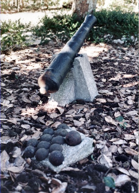
Poitevent cannon
It is generally believed that this small naval artillery gun, whose tube is 4 ¼ feet long, and was located pre-Katrina in the small garden in the rear of the Poitevent-Mavar estate at 321 Lover’s Lane, was also taken off the sunken French supply ship situated on the "rock pile” in Biloxi Bay. A collection of twelve cannon balls, ranging in diameter from 3 inches to 4 ½ inches are set in a cement block adjacent to the cannon. Other families domiciled along the Biloxi Bay front of Lover’s Lane have found larger cannon balls and other French Colonial artifacts. Image made February 1997 by Ray L. Bellande.
Artifacts recovered-Non-indigenous stones and boulders which were probably ballasts for the vessel. Some firm brick-8 inches long, 4 inches wide, and 1 3/8 inches thick. A large number of iron braces—12 feet long, 2 ¼ inches wide, and ½ inch thick. A 9 inch diameter sheave with a one inch groove and block 12 inches, also a small one. Both made from different wood used at the time. A 12 inch block eye and others about half this size. These indicate a vessel of large tonnage. Four cannons- One 6-foot long bore with a 3 ½ inch muzzle in fair condition. "H.E. or F.O.S." are discernible and located about one foot from the vent. A small amount of gunpowder was fired from the gun by the fisherman. One 7-foot long bore with part of the hard wood, gun carriage attached to the right side. Two 4 feet in length with a 2 ½ inch bore and each badly eroded by rust. Cannon balls: a 2 inch, 2 ½ inch, and 3 inch cannon ball were found. Muskets: Several muskets capable of firing a one ounce ball were found. Their locks were described as very old fashioned, the nipple and vent perfect. Gunpowder: A quantity of gunpowder in chunks located which retained its original odor. Miscellaneous objects: a water cask bung stopper made of several thicknesses of woolen cloth and a scabbard of an officer’s sword which retained much of its original shape.(The Pascagoula Democrat Star, September 23, 1892, p.2 and The Biloxi Herald, September 24, 1892, p. 1)
Unfortunately, very little of the salvaged objects from the sunken ship in Biloxi bay remain today. The most visible are the four, oxidizing cannons formerly embedded in concrete at the Villa Santa Maria on East Beach Boulevard at Biloxi. They were placed here before 1931, when the Biloxi Community House stood on this site. These cannon were removed from their Villa Santa Maria venue and placed across US 90 in the Purple Heart Memorial at the Biloxi Small Craft Harbor.
Another interesting facet of this story was the cannon in the yard of the Poitevent home on the Fort Point peninsula. It is generally believed that this small naval artillery gun, whose tube is 4 feet and 3 inches long, and was located pre-Katrina in the small garden in the rear of the Poitevent-Mavar estate at 321 Lovers Lane, was also taken off the "rock pile." A collection of twelve cannon balls, ranging in diameter from 3 inches to 4 ½ inches are set in a cement block adjacent to the cannon. Anecdotal family history states that the weapon was set up in the Poitevent garden in 1892, and fired in celebration of the results of the 1896 presidential election. The resulting explosion caused windows in the Poitevent home to shatter. They were replaced by new panes brought from New Orleans (Personal Observation-measurements and sketches made by Ray L. Bellande-February, 1997 and The Daily Herald, May 5, 1970, p. 15)
Sunken vessel
The theory most often proposed by historians as to the origin of the sunken vessel on the "rock pile" in Biloxi Bay is that it was a victim of the Hurricane of September, 1722. Jean-Baptiste Bernard de la Harpe, a French soldier who served in the Louisiana Colony from1718 until 1723, kept a journal during his tenure here. He wrote on September 11, 1722:
A hurricane began in the morning which lasted until the 16th. The winds came from the southeast passing to the south and then to the southwest. The hurricane caused the destruction of beans, corn and more than 8,000 quarts of rice ready to be harvested. It destroyed most of the houses in New Orleans with the exception of a warehouse built by M. Pauger. The warehouse of Fort Louis (present day Biloxi) containing a large quantity of supplies, was overturned to the great satisfaction of its keepers. The accident freed them from rendering their accounts.
The Espiduel, three freighters, and almost all of the boats, launches, and piroques perished. The Neptune and the Santo-Cristo, which had been repaired according to the orders of the commissioners, were entirely put out of service. A large supply of artillery, lead, and meats which had been for a long time in a pincre, were lost near old Biloxi (Ocean Springs). The French had neglected to unload the ship for more than a year. They were also worried about the three ships anchored at Ship Island and the Dromadaire, which had been sent to New Orleans loaded with a supply of pine wood, which would have cost the company more than 100,000 livres. (Jean-Baptiste Bernard de la Harpe, 1971, pp. 214-215)
The most recent investigation that this writer is cognizant at the "rock pile" site, north of the CSX Railroad Bridge off Lovers Lane, occurred in 1997. The Sun Herald and The Mississippi Press in late January, 1997, announced that the Senate of Mississippi voted to appropriate $50,000 to the Mississippi Department of Archives and History to fund research to determine if a sunken 18th Century vessel, located in Jackson County waters just off the shoreline of Ocean Springs, belonged to the 1698-1699 fleet of Pierre Le Moyne Sieur d’Iberville. In addition, some of the money was spent to estimate the cost to salvage the derelict, if warranted. (1,2)
In December 1972, Gulf South Research Institute of Baton Rouge, Louisiana, under contract to the Mississippi Department of Archives and History, had run a magnetometer survey across a two-acre, rectangular site recommended by Dr. Charles K. Eleuterius (1940-2003), a physical oceanographer, at the Gulf Coast Research Laboratory in Ocean Springs. Dr. Eleuterius was the great grandson of Captain H. Eugene Tiblier who salvaged artifacts from the wreck in 1892. Jack C. Hudson, Historical Site Archeologist, with the consulting firm, reported to Elbert R. Hillard, Director of the Mississippi Department of Archives and History, that a plot of the magnetometer survey data demonstrated many areas of high intensity readings in the northwest quadrant of the survey area. This is the location that Dr. Eleuterius predicted where the sunken vessel would lie, prior to the geophysical survey.(Gulf South Research Institute, January 12, 1973)
Mr. Hudson, consulting archeologist, speculated that if the sunken vessel in Biloxi Bay was preserved in the silt as anticipated, it would be to his knowledge, "the earliest intact colonial ship extant." This aspiration no longer exists for Mississippi as in late January 1997 archaeologists of the Texas Historical Commission recovered two 800 pound bronze cannons from La Belle in Matagorda Bay on the lower Texas coast. The weapons bear the crests of Louis XIV and Le Comte de Vermandois, Admiral of France from 1669-1683. La Belle was the vessel that René Robert Cavalier, Sieur de La Salle (1643-1687) commanded in 1684 in his search for the Mexican Gulf outlet of the Mississippi River that he had discovered in 1682 by voyaging downriver from Canada.( Gulf South Research Institute, January 12, 1973 and The Sun Herald, February 2, 1997, p. A-2)
From the current historical and anecdotal information available, it would appear that there are several small-medium sized vessels of the early Louisiana French Colonial Period (1699-1724) located in the mud and silt-laden bottom of Biloxi Bay. Were these "mystery ships" associated with the 1698-1699 expeditionary flotilla of Iberville, victims of the 1722 Hurricane, or neither?
Dunbar Rowland announcement
In May 1905, Dunbar Rowland (1864-1937), director of the Mississippi Department of Archives and History, came to the Mississippi Gulf Coast and to Ocean Springs in particular. Here he announced that he was convinced that Fort Maurepas had been situated: “on a beautiful spot, much higher than the surrounding country, covered with magnificent oaks and magnolias of great age, it overlooks the bay coast of Biloxi, from which place it is one mile across the water. It is in the corporate limits of Ocean Springs and near the settlement of Old Biloxi. One cannon still remains on the embankment, which is constantly caving into the water, attest that the site of the battery was at that point and the present high ground only a part of the original site.”(The Pascagoula Chronicle, May 20, 1905)
The author believes with a high degree of certitude that Dunbar Rowland was describing the Schuyler Poitevent (1875-1936) property at 309 Lover’s Lane. As Mr. Poitevent had uncovered thousands of French Colonial artifacts here and had been a member elect of the Mississippi Historical Society since 1890, he certainly would have had Mr. Rowland’s ear.
Old Fort Maurepas remembered
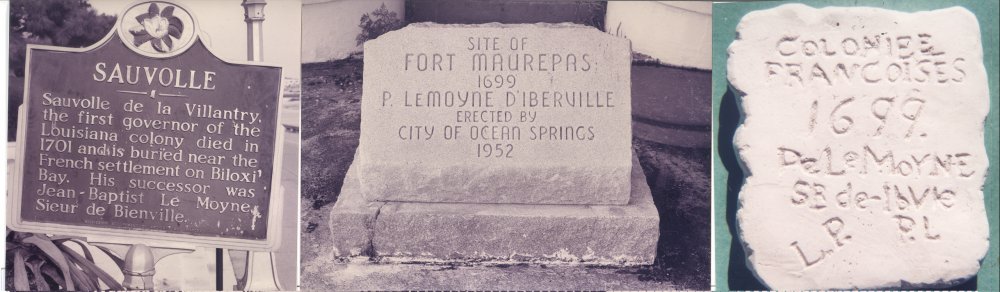
These Ocean Springs historical markers are some of the reminders of our French Colonial heritage that are in the public venue.[L-R: ‘Sauvolle’ marker and ‘Site of Fort Maurepas’ marker were formerly on Front Beach Drive. They were ‘moved by’ and after Katrina in August 2005 and have not been returned to their setting at the ‘Elephant Walk’, a recent moniker for the stairs that climb the bluff from between 231 and 235 Front Beach Drive north to Schmidt Street. Both are secure at OS Public Works on Pine Street. The last image is the iconic ‘cornerstone of Fort Maurepas’ found in the water near the ‘Elephant Walk’ in 1910 when it was it was owned by the Heirs of W.B. Schmidt (1823-1901). The original artifact remains in New Orleans at the Louisiana State Museum who borrowed it from F.A. ‘Dolph’ Schrieber (1871-1944) in May 1937. Images made by Ray L. Bellande.
North Biloxi’s faux Iberville Monument
In Chapter XI of his unpublished “Broken Pot”, Schuyler Poitevent related the origin of the wooden cross and marker that in April 1920 were placed on the Back Bay of Biloxi in present day D’Iberville by the Gulf Coast Chapter of the Daughters of the American Revolution [DAR] to commemorate the 1699 landing of Pierre Le Moyne Sieur d’Iberville (1661-1706). The site chosen by the DAR is just east of the 1926 Biloxi Bay Bridge. Prior to selecting North Biloxi as the area was called in 1920, this organization approached Schuyler Poitevent and suggested that his property at 318 Lovers Lane be the site of the memorial to Iberville and Fort Maurepas. Mr. Poitevent vehemently opposed the idea. In response to this rejection by Poitevent, the local DAR chose to build their memorial in what would become the schoolyard of St. Theresa’s Catholic School. Fortunately this travesty has been removed and now rests ironically in a glass case in the Sacred Heart Catholic School on LeMoyne Boulevard in D’Iberville.
Polish monument
In the summer of 1935, Dr. Dunbar Rowland, Mississippi Department of Archives and History director, requested that Anthony V. Ragusin (1902-1997) of the Biloxi Chamber of Commerce, obtain a soil sample from the historic Poitevent property at Ocean Springs on Biloxi Bay. The Republic of Poland was erecting a large mound to honor Marshall Joseph Pilsudski (1867-1935), a soldier, revolutionary, and statesman. A committee in Chicago was also acquiring dirt from other American historic sites and Dr. Rowland was to take the soils to Poland and incorporate it into the Pilsudski mound.(The Daily Herald, July 6, 1935, p. 2)
Death
Schyuler Poitevent died at the age of sixty-one years on October 14, 1936, at the Mercy Hospital in New Orleans probably of cancer. His corporal remains were passed through St. John’s Episcopal Church and interred in the family plot at Ocean Springs in the Evergreen Cemetery. Mr. Poitevent had had a throat operation in New Orleans in December 1933.(The Jackson County Times, December 16, 1933, p. 3 and October 17, 1936)
National shrine?
In the spring of 1937, a group of local citizens were making serious overtures to have the site of where they believed Fort Maurepas had been erected in April 1699, recognized as a national shrine. The Federal government would not be asked for financial assistance, unless the solicitation of private contributions proved unsuccessful. (The Jackson County Times, June 26, 1937, p. 1)
At this time, this aspiration did not come to fruition, but was manifested in August 1952 with the laying of a stone marker on Front Beach at the ‘Elephant Walk’, a recent moniker for the concrete landing and stairs leading from Front Beach Drive to Schmidt Street atop the bluff overlooking Biloxi Bay. As previously mentioned this venue was very near the place that the alleged ‘cornerstone’ to Fort Maurepas was discovered by Marshal Rupp in 1910. This ‘artifact’ was publicly revealed to the community much later by F.A. ‘Dolph’ Schrieber (1871-1944), a former lighthouse keeper, and Marshal Rupp’s son-in-law. It is common knowledge that the ‘1699 stone’ was taken in May 1937 to New Orleans for historical validation by James J.A. Fortier, president of the board of curators of the Louisiana State Museum. Dolph Schrieber had loaned ‘the stone’ to Dr. Oscar Lee Bailey (1870-1938) to display in the Bailey Drug Store, now Lovelace Drugs, on Washington Avenue. It remains at the Cabildo in New Orleans today as a ‘trophy in exile’ of Louisiana Colonial history. Do we rally want it back??(The Jackson County Times, May 28, 1937 and June 26, 1937, p. 1)
Dream comes true
What a small cadre of zealots had desired for many years, the physical manifestation of a Fort Maurepas replica in Ocean Springs, began to gain momentum in the early 1970s. With the interest of J.K. Lemon Jr. (1914-1998) and Colonel (Ret.) Rudolph Fink (1905-1980), local historians, the research and archaeological investigations of Dale Greenwell of D’Iberville, and the nascent 1699 Historical Committee, who were all probably inspired by Jay Higginbotham, native of Pascagoula and French Colonial historian, who published Fort Maurepas: The Birth of Louisiana, (Colonial Books: Mobile-1968) and The Journal of Sauvole, (Colonial Books:Mobile-1969), the die was cast.
In the spring of 1973, the 1699 Historical Committee, State Representative Marby R. Penton (1922-1995), and Secretary of State Heber Ladner (1902-1989) were rewarded for their efforts to have Fort Maurepas replicated at Ocean Springs when the Mississippi Legislature passed House Bill No. 1361 which appropriated $300,000 to "purchase land for the location of the Fort Maurepas historical site, provided that said site is entered in the National Register of Historical Places". In the same year, archeologists from the Mississippi Department of Archives and History [MDAH] began a survey to locate the site of Fort Maurepas. Most of their efforts were concentrated in the Lover's Lane area of west Ocean Springs.(The Ocean Springs Record, March 31, 1973, p. 1)
The Gulf Regional Planning Commission at Gulfport released its report titled, "Reconstruction of Fort Maurepas", also in March 1973. This detailed study which was prepared for the City of Ocean Springs and the 1669 Historical Committee focused on the history and significance of Fort Maurepas, the costs to acquire land and the erection of a historically accurate replica. Volney J. Cissna (1917-2002) and Ralph E. Hode were significant contributors to this treatise.(The Ocean Springs Record, March 1, 1973, p. 1)
Fort hunt
In July, 1973, Donald L. ‘Pat’ Connor (1912-1982) and Ethelyn MacKenzie Shaffner Conner (b. 1916), his wife, unlike many residents on ‘The Lane’, allowed archaeologists from the Mississippi Department of Archives and History to conduct excavations at ‘Conamore’ their homestead fronting Biloxi Bay. Trenching was done in an attempt to locate the remains of Fort Maurepas. Although not successful in finding the old fort, the archaeological survey did reveal a large feature. Radio carbon dating of charred posts from the structure indicated it to be 1755 AD, (plus or minus 55 years) in age. Several faience shards, gun flints, and a colonial brick were discovered on the Connor property. In addition, Mrs. Ethelyn M. Connor has three seven pound cannon balls that were found by her sons on the beach in front ‘Conamore’.(The Ocean Springs Record, December 6, 1973, p.1, Elbert R. Hilliard, January, 1974, pp. 6-7 and Personal Communication: Ethelyn Connor to Ray L. Bellande-July, 1992)
Although trenching occurred on ‘Conamore’, conclusive evidence for the old French structure was never discovered. One theory why indications of the remains of Fort Maurepas were not found was that the scientists were not allowed to explore a particular location, the Poitevent family lot, where cartographic and surface evidence indicated the old French fort to be situated. Others believed that the original site of Fort Maurepas on the high bluff facing Biloxi Bay on the Poitevent property was eroded long ago by wave action and violent storms.
Last dig?
The last archaeological investigation sanctioned by the Mississippi Department of Archives and History ‘on The Lane’ occurred in November 1998. At this time, Ginette Poitevent, a resident of Mandeville, Louisiana and the widow of Eads Poitevent (1919-1996), allowed a small cadre of volunteers, who were supervised by Jack Elliott, historian-archaeologist with MDAH, to dig a shallow trench on her land. Mrs. Eads Poitevent had inherited ‘Bay View’, the 1877 built, home and estate of Junius Poitevent (1837-1919) at 309 Lovers Lane from Virginia Margaret Favre (1912-1990), the widow of Schuyler Poitevent (1911-1978).(The Mississippi Press, November 16, 1998, p. 1)
Virginia F. Poitevent had lived at ‘Bay View’ in Ocean Springs until her health deteriorated. Her final years were spent at Mandeville, Louisiana in the care of Mr. and Mrs. Eads Poitevent. Before she passed in late July 1990 at Mandeville, Louisiana, Mrs. Virginia M. Poitevent donated a series of one hundred twenty-eight arrow points, spear heads, and other American Indian stone cut objects to the Musee Du Nouveau Monde at La Rochelle, France. To the Tulane Center for Archaeology at New Orleans, she gave a collection of French Colonial and Native American artifacts. The Mississippi Department of Archives and History was the recipient of the Poitevent Papers, which includes manuscripts, diaries, correspondence, essays, and photographs of the June Poitevent Family. (The Sun Herald, August 3, 1990, p. B-2 and JXCO, Mississippi Chancery Court Cause No. P-0000-2806-2000)
The November 1998 dig on the Poitevent tract found French Colonial artifacts, pipe stems, beads, pottery shards, and one gun flint, all indications of an early French presence. Jack Elliot of MDAH said that: “French artifacts will not identify the site [of Fort Maurepas].”(The Mississippi Press, November 16, 1998, p. 1)
Bed and Breakfast
In the spring of 1993, Ginette Poitevent announced plans to commence a bed and breakfast establishment in the Junius Poitevent house on Lovers Lane. She envisioned combining the French Colonial history of her property, its vista of Biloxi Bay, and the seclusion of “The Lane” to attract a more cerebral tourist. In addition to a four to six bedroom guest house, Mrs. Poitevent had a scheme to erect a Fort Maurepas museum on the site. Tulane University and the Mississippi Department of Archives and History were to assist with the museum.(The Mississippi Press, May 7, 1993, p. 2-A)
After Mrs. Poitevent’s bed and breakfast plans were announced, her aspirations were soon squelched by the residents of “The Lane”. Their negativity towards this project was expressed at a meeting of the City Planning Commission in May 1993. The Planning Commission was in general agreement to allow bed and breakfast operations as a Special Use in R-1 zoning situations. Ginette Poitevent yielded to her neighbors concerns of excess traffic, noise, and other disturbances real or imagined that might result from a commercial operation in their serene neighborhood. Ginette Poitevent sold ‘Bay View’ in April 2000 Alfred “Fred” R. Moran Jr. Several days later, Mr. Moran conveyed this historic home and very probably the 1699 location of Fort Maurepas to Geoffrey P. Mavar. Geoffrey P. Mavar (b. 1962) is the son of Victor Mavar and Gayle Mavar of Biloxi.(The Sun Herald, May 11, 1993, p. C-1 and The Ocean Springs Record, May 13, 1993, p. 1 and JXCO, Ms. Land Deed Bk. 120 , p. 294 and p. 502)
Land purchase
By 1975, Fort Maurepas zealots saw the Mississippi Legislature apportion $250,000 to the State Building Commission to acquire a site for a Fort Maurepas reconstruction at Ocean Springs to be administered by the Department of Archives and History. With this money, two tracts of land on Front Beach at Ocean Springs between Washington Avenue and Jackson Avenue were purchased in February and March of 1976 by Governor Charles Clifton ‘Cliff’ Finch (1927-1986) and Secretary of State Heber Ladner representing the State of Mississippi. At this time, Heber Ladner was also chairman of the Mississippi American Revolutionary Bicentennial Commission. Governor Charles Clifton ‘Cliff’ Finch (1927-1986) and Secretary Ladner held a deed acceptance ceremony in the Capitol in early March 1976 with representatives from the State Building Commission, Department of Archives and History, Jackson County legislators, First National Bank of Jackson County, Ocean Springs Yacht Club, and the City of Ocean Springs present. Secretary Ladner lauded the State legislature for their unanimous support for the Fort Maurepas reconstruction, which had been designated a Mississippi Bicentennial project.(The Ocean Springs Record, February 27, 1975, p. 1March 11, 1976, p. 2)
The Hansell-Edwards House and New Beach Hotel
[L-R] The Hansell-Edwards House on Front Beach at Ocean Springs was probably built by Henry H. Hansell (1817-1878), a prominent ‘saddler’ from New Orleans. The widow, Sarah M. Richardson Hansell (1825-1908), sold it to James Daniel Edwards (1839-1887) in May 1885. Mr. Edwards made his livelihood as the proprietor of James D. Edwards Iron Works located at 22 to 34 South Front Street in New Orleans. Dr. Jasper J. Bland (1850-1932), a native of Yazoo County, Mississippi and the son-in-law of J.D. Edwards, acquired the house in 1899. He converted it into the Beach Hotel. In 1909, Dr. Bland hired local contractors, Frederick S. Bradford (1878-1951) and John Burr (1875-1916), to enlarge the structure to three levels. Completed in June 1909, Dr. Bland called his new inn the New Beach Hotel. His workmen presented him with a silk umbrella on opening day. In 1919, the Cabrini Sisters-Missionary Sisters of the Sacred Heart acquired the property and used it as an orphanage and later retirement home for their Holy Order. The old structure was demolished by Clarence E. Galle (1912-1986) after Hurricane Camille and The Missionary Sisters sold the large tract to the Richelle Corporation of Metairie, Louisiana in February 1974. A condominium project was planned by Richelle for the site. Courtesy of Harry Lucas Jr., grandson of Dr. Jasper J. Bland.
Hansell-Edwards home
The tract chosen for the Fort Maurepas replica on Front Beach at Ocean Springs had been the site of the Hansell-Edwards family summer home. By1850, Henry Holcombe Hansell (1817-1878), a native of Pennsylvania, was domiciled on St. Charles Avenue at New Orleans with Sarah Margaret Richardson Hansell (1825-1908), his wife, two sons, and daughter: Henry H. Hansell II (1848-1900+), William S. Hansell (1849-1911), and Margaret M. Hansell (1858-1878).(1850 Orleans Parish, Louisiana Federal Census M432_237, p. 264, Ward 2)
In the Crescent City, Mr. Hansell was a ‘saddler’. He expired at New Orleans in August 1878, and was lauded in his obituary as follows: “known for his kindly nature and honorable character, which won for him the high regard of his fellow men. As proprietor of one of the oldest and most extensive saddlery houses in the City, he occupied a notably responsible position, the duties of which he discharged with superior judgment.” .(The Daily Picayune, August 17, 1878)
In January 1880, the heirs of H.H. Hansell were continuing to advertise their saddle and harness business in the Crescent City:
H.H. HANSELL
Manufacturer of
SADDLERY and HARNESS
and Importer and dealer in
SADDLERY HARDWARE, LEATHER, BELTING HOSE, ETC.
Government Harness, Saddles, etc.
No. 22 Magazine and 74 Common Street
New Orleans, La.
(The Pascagoula Democrat-Star, January 23, 1880, p. 4)
James D. Edwards
In May 1885, James Daniel Edwards (1839-1887), acquired the Henry H. Hansell summer home at Ocean Springs on the beach between Jackson and Washington Avenue from Sarah Margaret Richardson Hansell, the widow of Henry Holcombe Hansell. The consideration was $2800.(JXCO, Ms. Land Deed Bk. 7, pp. 468-472)
Mr. Edwards made his livelihood as the proprietor of James D. Edwards Iron Works located at 22 to 34 South Front Street in New Orleans. This institution produced sugar machinery as well as copper, brass, and sheet iron work. Edwards employed a skilled work force numbering several hundred. Their machines were exported to Mexico, Cuba, and Central America. In addition, the firm was an agent for steam pumps, gauges, and locomotive and marine equipment. James D. Edwards died intestate on April 2, 1887 at New Orleans. In February 1899, Dr. Bland took a lease from the Edwards' heirs and opened a hostelry which he appropriately named the Beach Hotel. Lawrence Gautreaux, a seasoned hotel manager, was put in charge.
Later in 1899, Mary H. Haner Edwards (1845-1925), the widow of James D. Edwards, petitioned her children in the Chancery Court of Jackson County, Cause No. 804. The suit was filed to force a sale of the Edwards House in order for the respective heirs to receive their share of the property. Dr. Jasper J. Bland (1850-1932), the son-in-law of Mrs. Mary Edwards, purchased the Edwards summer home property from Special Commissioner, Frank H. Lewis (1865-1930) of Pascagoula, Mississippi, for $5500 in August 1899. Dr. Bland had married Agnes Elizabeth Edwards (1868-1936) in 1891.(JXCO, Ms. Land Deed Bk. 20, pp. 248-250)
Eventually, Dr. Jasper J. Bland (1850-193) enlarged the Beach Hotel to three stories renaming it the New Beach Hotel in 1909. By 1921, the Missionary Sisters of the Sacred Heart were occupying the site utilizing it as a summer orphanage. It later became their retirement home. Hurricane Camille damaged the structure in 1969, and it was torn down by Clarence E. Galle (1912-1986) in the summer of 1971. The Missionary Sisters sold a portion of their tract to the Richelle Corporation of Metairie, Louisiana in February 1974 (The Ocean Springs Record, July 22, 1971, p. 9 and.JXCO, Ms. Land Deed Bk. 448, p. 546).
The Richelle Corporation planned to develop the property as the Twin Bluff Condominiums, but were foreclosed on and sued by the First National Bank of Jackson County. The local bank was awarded title to the land by the Chancery Court and they sold it to the State of Mississippi on March 1, 1976.( JXCO, Ms. Chancery Court Case No. 29,412 and .(JXCO, Ms. Land Deed Bk. 554, pp. 644-645).
The Missionary Sisters conveyed their other contiguous parcel of about two acres on the east side of the tract to Donald M. Bradburn in September 1975. Dr. Bradburn later conveyed this land to the Ocean Springs Yacht Club who attempted to get a permit to build their yacht club here. After being denied this privilege by the City on several occasions, the local sailors relented and sold their land to the State of Mississippi on February 16, 1976, which completed their land acquisition for a site for erecting the Fort Maurepas replica.(JXCO, Ms. Land Deed Bk. 543, p. 387 and Bk. 554, pp. 646-647, Russell Thompson, former OSYC commodore, and The Ocean Springs Record February 19, 1976, p. 1)
Fort-pro and con
In 1975, the State Building Commission had hired William Hogg, consultant of Williamston, Michigan, to determine if the Fort Maurepas replica were erected in Ocean Springs would it be economical viable. His report indicated that if 200,000 tourists per year visited Fort Maurepas, the project should recover its development costs in several years. He estimated that an interpretive center of 2400 square-feet would necessary as well as $450,000 additional dollars for reconstruction and other land costs. This placed the cost of the project at about $750,000.(The Ocean Springs Record, January 22, 1976, p. 1)
Typical of Ocean Springs, as the ink was drying on the warranty deeds of the Fort Maurepas replica tracts, local opposition to the project surfaced. Marby R. Penton, president of the 1699 Historical Committee, recognized this nascent, negative cloud beginning to settle over the planned Fort Maurepas reconstruction. In late February 1976, he called his salient stalwarts together: Harry Del Reeks (1920-1982), Delores ‘Bobby’ Davidson Smith (1916-1997), and Donald L. ‘Pat’ Connor (1912-1982) to affirm the positive aspects of the project. Their talking points concerning the opposition were that the antagonists: didn’t understand the scope and State wide support; and didn’t realize the economic benefits to Ocean Springs in the form of tourism and generated tax revenues.(The Ocean Springs Record, February 26, 1976, p. 1)
Elbert R. Hilliard, director of the Mississippi Department of Archives and History, went on record that his organization also opposed the reconstruction of Fort Maurepas on Front Beach in Ocean Springs as a “historic preservation project” because the exact location of Fort Maurepas was never resolved from archaeological investigation held in 1973 in the Lover’s Lane area. In addition, the fact that credible documentary evidence as to what the ancient structure resembled had never been located. Mr. Hillard made it clear that “this department (MDAH) is not opposed to tourism. If the citizens and the public servants of this State want a ‘Fort Maurepas’ then they should have it. But is should not be represented as a historic preservation project and it should not be under the administration of the State’s official historic preservation agency.”
Ed Wilson of Gulf Hills prepared a ballot to determine the mass appeal or lack there of for the fort replica. It was published in the Ocean Springs Record on February 19, 1976 and gave the perspective voter three options: construct the fort at the chosen site on Front Beach; construct the fort replica at another site; do not build a fort replica anywhere. The results of this non-binding referendum were revealed in early March and overwhelmingly supported the construction of the replica of Fort Maurepas on Front Beach Drive. Mr. Wilson informed State representative Dempsey Levi and John Corlew and Son Rhodes, both State senators of these results.(The Ocean Springs Record, March 4, 1976, p. 1)
Fort Maurepas-
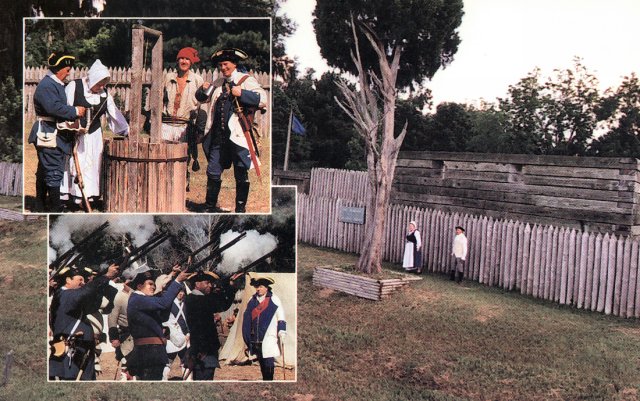
This 1990s postcard was made by the Fort Maurepas Society as one of their fund raising efforts to assist with the preservation of the fort replica which was never completed by the State, nor the City of Ocean Springs. The Fort Maurepas Society had ‘living history programs’ for school children and the general public for about seven years. Gloria Smith Moran (1924-1999) and John D. Moran (1919-1999), her spouse, residents of Delisle and seen in the main fort image, worked untiringly for many years to promote French Colonial History and Fort Maurepas. In the upper inset image around the well are society members: [L-R] Harold Rogers; Gloria Smith Moran; Ray L. Bellande; and H. Bradley Heitzman, MD. In the lower inset are French marines from Fort Maurepas and Fort Toulouse in Wetumpka, Alabama firing their muskets.
Fort Maurepas replica
In March 1979, the State Legislature appropriated $300,000 for the construction of the Fort Maurepas at Ocean Springs. State Representative Dempsey Levi had attempted to have a $1,200,000 bill for the fort replication passed, but Fort Maurepas zealots had to settle for the lesser amount.(The Ocean Springs Record, January 25, 1979, p. 1 and March 29, 1979, p. 3)
Fred Wagner of Bay St. Louis was named project architect and the New Orleans firm of Koch & Wilson associate architects. In September 1980, the State Building Commission awarded a contract for $273,000 to the Carter & Mullins Construction Company of Columbia. House Bill No. 1296 (March 1981) allowed for $950,000 in Federal revenue sharing funds to complete Fort Maurepas.(The Ocean Springs Record, July 10, 1980, p. 1, August 7, 1980, p. 2, and September 9, 1980, p. 1)
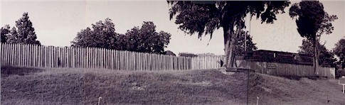
The first phase of construction was completed in August or September of 1981. It consisted of an exterior stockade (154 feet x 154 feet) constructed of single, treated pine post about eight feet tall. The square enclosure encompassed an area of about .54 acres. The southeast corner of the Fort Maurepas replica was a blockhouse or bastion (Royal Bastion). It was triangular in plan about twenty feet tall and served as the Governor's House and cannon fortification. No other bastion was commenced. The only portion of the inner palisade that was completed was a twenty eight-foot section, which runs west of the Royal Bastion and included the main gate (seven feet wide). This wall was approximately twelve feet tall and was built triple log thick. No interior buildings were ever constructed, i.e. soldier's lodges, bakery, or general warehouse.(The Ocean Springs Record, January 22, 1981, p. 2 and December 17, 1981, p. 1)
Unfortunately in 1982 and 1983 the Mississippi Budget Commission took measures to avert State budget deficits. With a deficit of $85 million facing them in 1983, the Commission approved a $9 million cut in agency appropriations, which included $900,000 for the completion of Fort Maurepas.(The Ocean Springs Record, January 13, 1983, p. 1 and March 21, 1985, p. 2)
At a town meeting held in Pascagoula in March 1986, US Representative C. Trent Lott related to the attendees that he planned to discuss the inclusion of the Fort Maurepas reconstruction at Ocean Springs with Donald P. Hodel (b. 1935), Secretary of the Interior. Representative Lott hoped to persuade Mr. Hodel that this structure be included in the Gulf Islands National Seashore system. Also at this time, Aubrey Rozzell, State Parks Director, had offered to lease the replica’s six-acre site to the City of Ocean Springs. The City had no interest in this proposal and GINS also rejected the offer to place Fort Maurepas into the park system in August 1986.(The Sun Herald, March 23, 1986, p. A2 and The Ocean Springs Record, August 28, 1986, p. 1)
When Hurricane Katrina devastated the incomplete Fort Maurepas replica in August 2005, it had set for almost a quarter of a century in its original state. The Fort Maurepas Society led by Harold Rogers and with the kind assistance of Glenn Young Jr., KAFB volunteer airmen and the OS Public Works Department had made minor repairs and improvements between 1992 and 1998.
Le petit Fort that no one wanted!
When looking at Fort Maurepas and its place in history, one comes to realize that the locating of Fort Maurepas at Ocean Springs by Iberville was an accident! The erection of its replica on Front Beach at Ocean Springs in 1980-1981 has also been criticized by many and the Mississippi Department of Archives and History [MDAH] in particular. It is only the current results of the ‘economic miracle’ of Katrina that has brought about what we hope is the final page in ‘the Fort Maurepas saga’-Fort Maurepas Park, a pro bono publico venue that most all will be pleased and enjoy.
From February 1699 until April 1699, Iberville and his cohorts explored the Mississippi River delta to as far north as St. Francisville, East Feliciana Parish, Louisiana and eastward from Istrouma [Baton Rouge] to Dauphine Island and Mobile Bay, with the aid of local Indian tribes discovering: Lake Pontchartrain and the Bayou St. John portage from a site on the Mississippi River to Lake Pontchartain. This river locale would become Bienville’s great city of New Orleans. As their provisions became exhausted, the Frenchmen had to hurriedly decide where to erect a fort and leave about eighty men to defend the French claim to much of what is now the central USA. Ocean Springs was actually the third choice for Fort Maurepas after sites on Lake Pontchartrain and at Gautier, Mississippi on the West Pascagoula River were negated. Mitigating circumstances primarily: distance from the fleet’s base at Ship Island; shallow water, and oyster reefs all led Iberville to choose the high bluff on today’s Lover’s Lane in Ocean Springs as the French beachhead in La Louisiane.(McWilliams, 1981, pp. 89-92)
It is the author’s hope that this history of past and present events relating to Fort Maurepas and Fort Maurepas Park has enlightened those who care about our past and future. May every citizen enjoy the benefits that Fort Maurepas Park will provide. If you do nothing but climb the stairs, the view of Biloxi Bay and Deer Island are worth the effort. Please thank our Mayor, her loyal and brilliant staff, your Aldermen, and FEMA! Vive Le Roi-Vive La France-Vive Les Ocean Springs. AuRayvoir.
Fort Maurepas (1699-1702) and French Colonial History at Ocean Springs
A Reconstructed French Colonial Fort
On April 8, 1699, an expeditionary force of French soldiers, sailors, and laborers with their French Canadian cohorts commenced construction of the first French fortress in the lower Mississippi River Valley. These brave men were led by Pierre LeMoyne, Sieur d'Iberville et d’Ardillières (1661-1706), him self a native of Canada, operating under the patronage of King Louis XIV (1638-1715) of France. Iberville's mission was to locate the mouth of the Mississippi River and establish a French presence on the Mexican Gulf Coast to discourage Spanish and English incursions into the area claimed by France. Some French strategist feared that if the English controlled the mouth of the Mississippi that their holdings and commercial enterprises including the lucrative fur trade of interior North America were doomed.
The basis of the French claim was the exploration by Robert Cavelier, Sieur de La Salle (1643-1687). La Salle reconnoitered the Mississippi River locating its deltaic mouth in April 1682. He claimed for France the vast area between the Rocky Mountains and the Alleghenies drained by the Mississippi and all of its tributaries. We know this territory as Louisiana, i.e. belonging to Louis (Louis XIV). La Salle called the Great River, Colbert, in honor of the French Minister of Marine.
The small fort was located on a narrow peninsula on the east side of the Bay of Biloxi within the present day limits of the city of Ocean Springs, Mississippi. Iberville named this French Colonial outpost, Fort Maurepas. It was named to honor the French Minister of the Marine (Navy), Jerome Phelypeaux de Maurepas, Comte (Earl) de Pontchartrain.
Several locales in North America bear the name Maurepas or Pontchartrain: Lakes Maurepas and Pontchartrain in southeastern Louisiana and Point Maurepas on the island of Michipicoten (Ontario) in Lake Superior. The Fort Maurepas settlement was also called Biloxi for the local Siouxan Indian tribe which lived on the Pascagoula River.
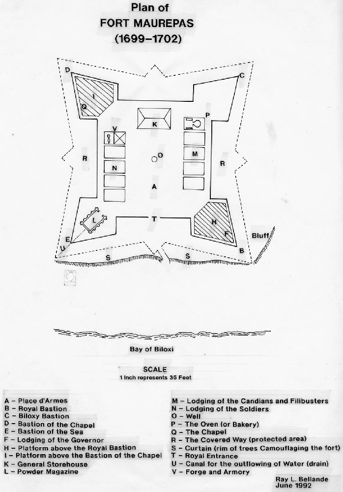
Plan of Fort Maurepas by Remy Reno
Fort Maurepas was designed by Remy Reno, the draftsman of Iberville, utilizing the system of military fortification developed by Marshall Vauban, nee Sebastian Le Prestre (1633-1707). Iberville's men utilized available materials for the fort's construction which covered an area of one-half acre. Bastions, palisades, living quarters, warehouses, and other structures were fabricated from indigenous trees, i.e. oak, hickory, and pine. Maurepas was armed with at least twelve cannon (possibly eight pounders) taken from the French frigates, La Badine and Le Marin.
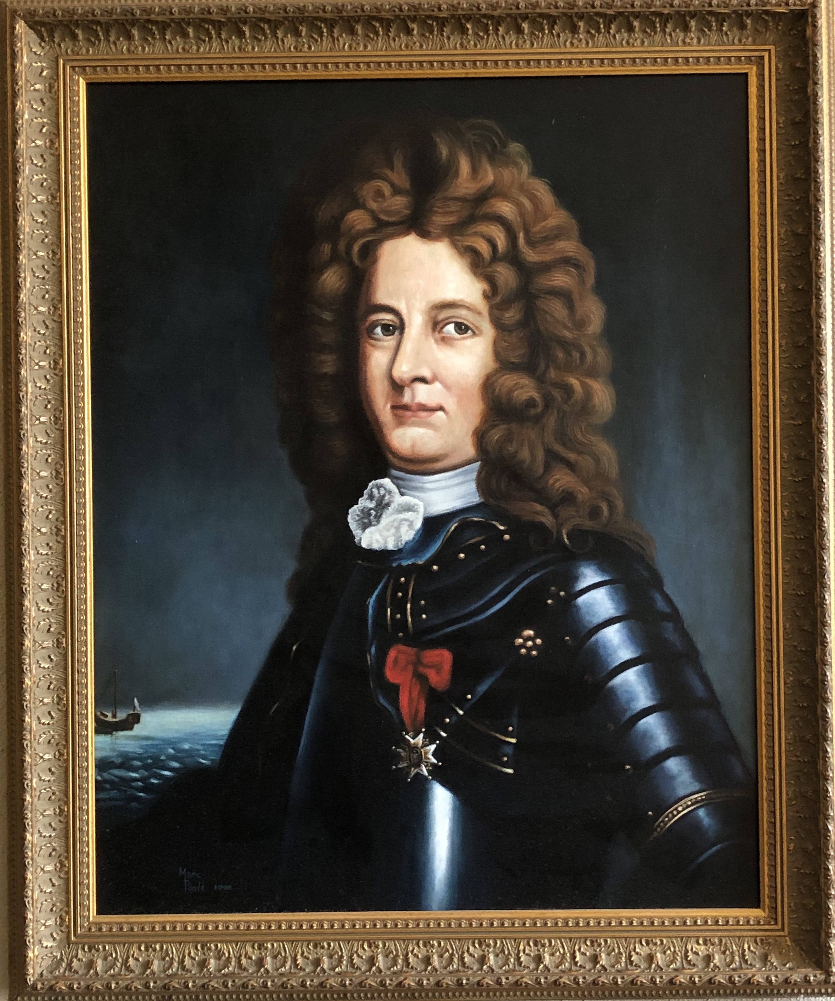
Pierre LeMoyne, Sieur d'Iberville et d’Ardillières
[portrait by Marc Poole, art director of MGCCC-Gautier campus]
When Iberville departed for France in May 1699, he left a garrison of seventy-six men and ten officers. They were given cows, hogs, a bull, seed (peas, corn, and beans), and ship stores to survive until his anticipated return in 1700. The crops planted failed due to a severe drought, but fortunately the garrison was supplied from the French base at St. Domingue (Haiti). Monsieur Sauvole was left in command with Jean Baptise LeMoyne, Sieur de Bienville (1680-1768), the brother of d'Iberville, second in command.
During Iberville absence, Bienville explored the surrounding area making brief stops at Pensacola, Mobile Bay, Pascagoula River, Lake Pontchartrain, and the Mississippi River discovering the future site of New Orleans. On the Great River, he encountered an English corvette, Carolina Galley, and convinced Captain Bond and his Huguenot settlers to retreat back to the Gulf.
This point of detour just south of New Orleans is still called English Turn (Detour-a-l'Anglais), and marked the commencement of a long period of time (1699-1763) in which the French controlled the Mississippi Valley from the Rocky Mountains to Biloxi. Iberville returned to Fort Maurepas in January 1700 aboard Renommee. The report of an English ship in the Mississippi River gave strong impetus for the Frenchmen to construct a small fort there. Fort Mississippi (Boulaye) (1700-1707) was completed in the spring of 1700.
Under Commandant Sauvole, the French continued good relations with the local Indian tribes in the vicinity of Fort Maurepas. They traded European goods (guns, axes, powder, etc.) for food and animal skins while absorbing the wood lore and culture of the Indian.
Conditions at Fort Maurepas were generally miserable as insects (gnats and mosquitoes), snakes, alligators, disease (especially yellow fever), and the paucity of drinking water were prevalent. In addition morale was low as the Canadians long accustomed to trapping and voyaging refused to farm. Drinking of spirituous liquor was also a problem.
By 1701, Iberville decided to move the garrison to a site on the Mobile River at Twenty Seven Mile Bluff. This settlement called La Mobile (Fort Louis de la Louisiane), for the local Indians, was established in the spring of 1702.
Locating here allowed the French to be nearer the Spanish settlement at Pensacola. France and Spain had recently become allied and had initiated a conflict with England called the Queen Anne's War (1702- 1713) in North America. Another advantage at La Mobile was that the river gave them access to the interior of Alabama were trading with larger Indian nations was possible.
Fort Maurepas was abandoned in the early months of 1702. It is generally believed that the structure was burned or dismantled to prevent an enemy of the French to utilized it. The French returned their capital to the area of the "Old Fort" at Ocean Springs briefly in 1719 before establishing a post (Fort Louis) at Biloxi in 1720.
1949 Historical marker
On November 20, 1949, an historical marker commemorating the establishment of Fort Maurepas by Iberville at Ocean Springs in April 1699 was placed on US Highway 90 and Front Beach Drive. Iola Y. Davidson spoke on the history of the French Beachhead followed by Mrs. Charles McDaris of Gulfport, representing the DAR. John D. Smith, Southern District Highway Commissioner, also spoke about the Fort Maurepas marker.(The Daily Herald, November 21, 1949, p. 1)
Local interest in Fort Maurepas began in 1967 when Colonel Rudolph Fink and J.K. Lemon began collecting maps and charts from the Bibliotheque Nationale in Paris. This information was shared with the history aficionados of the Gulf Coast resulting in an interest to locate the original site of Fort Maurepas.
1699 Historical Committee
In March 1971, a group of citizens organized at Ocean Springs to promote an interest in historical events of the past, present, and future of the Ocean Springs, Mississippi area. This association was called the 1699 Historical Committee. The 1699 Historical Committee is responsible for the annual Iberville Landing Commemoration (April), seeks to have the Fort Maurepas marker returned from the Cabildo, and was instrumental in the Fort Maurepas replication.
In 1973, the 1699 Historical Committee, State Representative Marby R. Penton (1922-1995), and Secretary of State Heber Ladner (1902-1989) saw their years of work come to fruition when the Mississippi Legislature passed House Bill No. 1361 which appropriated $300,000 to "purchase land for the location of the Fort Maurepas historical site, provided that said site is entered in the National Register of Historical Places". In the same year, archeologists from the Mississippi Department of Archives and History began a survey to locate the site of Fort Maurepas. Most of their efforts were concentrated in the Lover's Lane area of west Ocean Springs.
Although some trenching was done, conclusive evidence for the structure was never discovered. One theory why the fort was not found was that the scientists were not allowed to explore a particular location (Poitevent) where cartographic and surface evidence indicated the fort to be situated. Others believe the original site of Fort Maurepas on the high bluff at Fort Point was eroded long ago by wave action and violent storms.
The Gulf Regional Planning Commission released its study titled, "Reconstruction of Fort Maurepas", also in 1973. This detailed study dealt with the history and significance of Fort Maurepas, and the costs to acquire land and build an historically accurate replica.
By 1975, Fort Maurepas zealots saw the Mississippi Legislature apportion $250,000 to the State Building Commission for a site to be administered by the Department of Archives and History. With this money, two tracts of land were purchased in February and March of 1976 by Governor Cliff Finch and Secretary of State Heber Ladner representing the State of Mississippi.(The Ocean Springs Record, March 11, 1976, p. 2)
The most westerly tract of approximately 5.7 acres was the former location of the Edwards' summer home. In 1899, Dr. Jasper J. Bland (1850-1932) bought the property, and opened the Beach Hotel (Jackson County Deed Book 20, pp. 248-250).
Eventually, he enlarged the structure to three stories renaming it the New Beach Hotel in 1909. By 1921, the Missionary Sisters of the Sacred Heart were occupying the site utilizing it as a summer orphanage. It later became their retirement home. Hurricane Camille damaged the structure in 1969, and it was torn down by Clarence Galle in 1971. The Missionary Sisters sold the tract to the Richelle Corporation of Metairie, Louisiana in February 1974 (Jackson County Deed Book 448, p. 546).
Richelle planned to develop the property as the Twin Bluff Condominiums, but were foreclosed on and sued by the First National Bank of Jackson County (Chancery Court Case No. 29,412). The Bank was awarded the land, which they sold to the State on March 1, 1976 (Jackson County Deed Book 554, pp. 644-645).
The other contiguous parcel of about two acres was sold by the Missionary Sisters to Donald M. Bradburn in September 1975. Bradburn later conveyed to the Ocean Springs Yacht Club who sold to the State on February 16, 1976. (Jackson County Deed Book 543, p. 387 and Book 554, pp. 646-647).
Fort Maurepas replica
In 1979, the State Legislature appropriated $350,000 for the construction of the Fort Maurepas replica. Fred Wagner of Bay St. Louis was named project architect and the New Orleans firm of Koch & Wilson associate architects. In September 1980, the State Building Commission awarded a contract for $273,000 to the Carter & Mullins Construction Company of Columbia. House Bill No. 1296 (March 1981) allowed for $950,000 in Federal revenue sharing funds to complete Fort Maurepas. The first phase of construction was completed in August or September of 1981. It consisted of an exterior stockade (154 feet x 154 feet) constructed of single, treated pine post about eight feet tall. The square enclosure encompasses an area of about .54 acres. The southeast corner of the Fort Maurepas replica is a blockhouse or bastion (Royal Bastion). It is triangular in plan about twenty feet tall and served as the Governor's House and cannon fortification. No other bastion was commenced. The only portion of the inner palisade completed is a twenty eight-foot section, which runs west of the Royal Bastion and includes the main gate (seven feet wide). This wall is approximately twelve feet tall and is built triple log thick. No interior buildings have been constructed, i.e. soldier's lodges, bakery, or general warehouse. Unfortunately in 1982 and 1983 the Mississippi Budget Commission took measures to avert State budget deficits. With a deficit of $85 million facing them in 1983, the Commission approved a $9 million cut in agency appropriations, which included $900,000 for the completion of Fort Maurepas. Since this time State and Federal funds for the completion of Fort Maurepas had been suspended indefinitely.
With the State of Mississippi apparently not financially capable of committing funds to complete the Fort Maurepas project, it was felt that if the City of Ocean Springs got title to the property something might be done to accomplish this goal. By February 1991, under the leadership of District 113 Representative, Alvin Endt, the House voted to transfer the title to the City of Ocean Springs. After Senate approval and Governor Ray Mabus's signature, Mayor Kevin Alves on April 25, 1991, received the quitclaim deed to the two tracts containing the Fort Maurepas Reconstruction from the State of Mississippi by the Department of Archives and History and Department of Wildlife, Fisheries, and Parks. The State of Mississippi retained all mineral rights and stipulated that the city maintain the fort as a historic site and include in its annual budget sufficient funds to maintain the structure. (Jackson County Deed Book 975, pp. 113-117).
A ceremony was held at the Fort Maurepas replica on July 21, 1991 where Mayor Kevin Alves accepted the title to Fort Maurepas from Archives and History representative, Elbert R. Hilliard. U.S. Representative Gene Taylor addressed the group and said that the fort was "worthwhile to the preservation of our heritage", and pledged his support on seeing the replica completed.
On August 20, 1991, the Environmental Concerns Committee of the Greater Ocean Springs Chamber of Commerce proposed to the City of Ocean Springs that the marsh, wetlands, contiguous upland and wooded habitats which were adjacent to Fort Maurepas be declared an "inner city" nature preserve. The City Council accepted the proposal, which additionally provided for the protection, management, and development of a natural history program for the area. Discouragement of activities which might degrade the aesthetics, biological, scientific, or educational value of the area surrounding Fort Maurepas was another goal. (Minutes of the City of Ocean Springs, Mississippi (8-20-1991), pp. 582-583).
Fort Maurepas Society
On June 10, 1992, an organizational meeting was held at the Ocean Springs City Hall to form the Fort Maurepas Society. The purpose of this group is to outfit, maintain, and complete the construction of Fort Maurepas. After a slow first year, the Fort Maurepas Society is progressing and plans to present the citizens of Ocean Springs with some interesting programs commencing this fall. They tell me that "a few good men" will be coming from Fort Toulouse in October. Be there!
Reenactments
After the formation of the Fort Maurepas Society, the Fort Maurepas replica became the site of annual reenactments for about ten years. In the spring of 1992, Commandant Ray L. Bellande went to the Fort Toulouse replica at the Fort Toulouse-Jackson Park near Wetumpka, Alabama and invited the French Colonial animators there to participate in the first reenactment at Fort Maurepas, which was held in early October 1993.
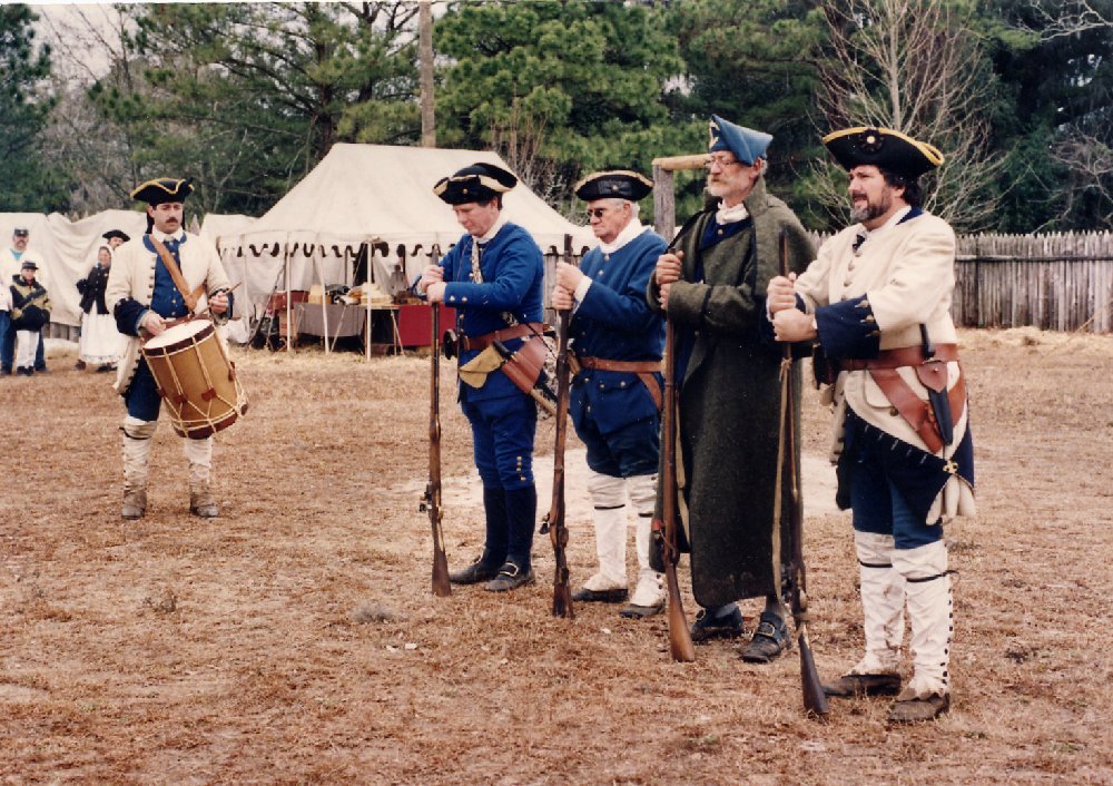
Compagnies Franches de la Marine performing manual of arms
(January 1994)
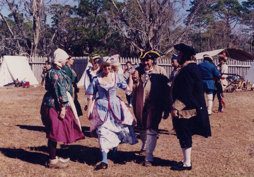
Fort Toulouse danseurs
(February 1995)
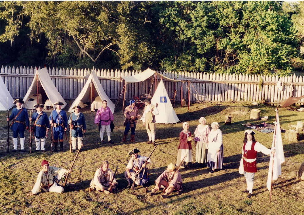
Arrival of Iberville
(October 1997)
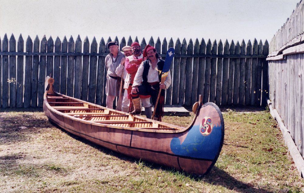
Ouisconsin Northwest Trading Company
(February 1999)
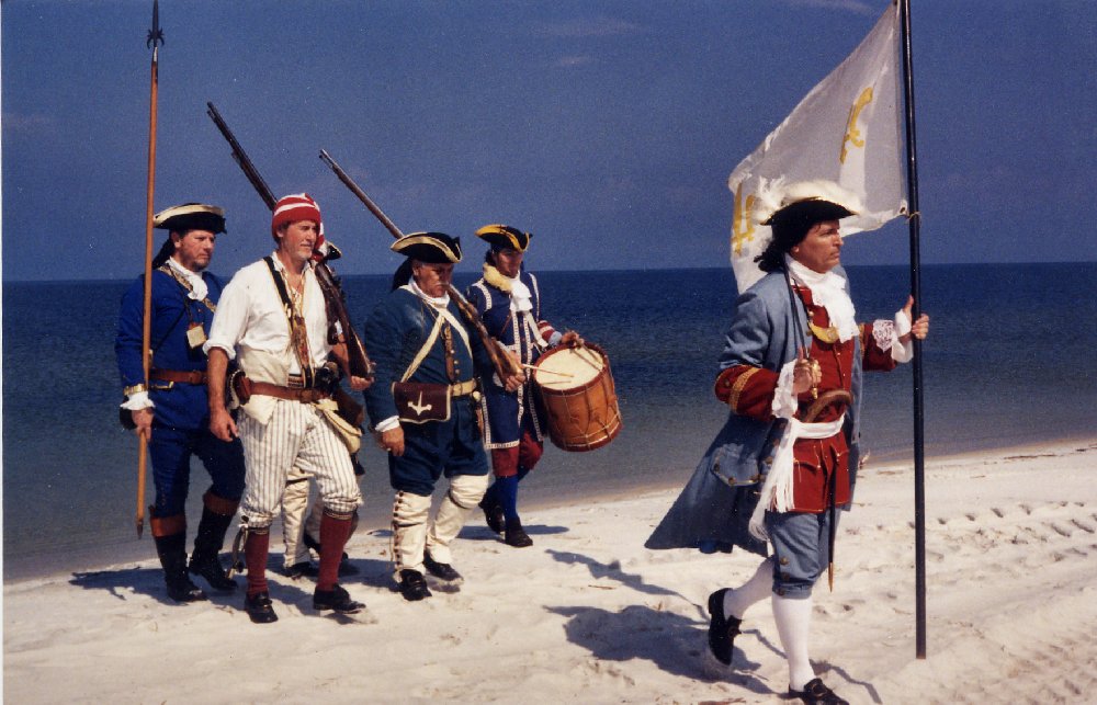
Iberville and French marines landing at Ship Island to commemorate the 300th anniversary of Iberville's landing
(February 1999)
Katrina-2005
In late August 2005, Hurricane Katrina essentially destroyed the Fort Maurepas replica on Front Beach Drive at Ocean Springs. The large bastion on the southeast corner of the structure was floated some forty-feet north of its foundation by the tempest. Most of the existing palisades were destroyed or severely damaged by the tidal surge on the morning of August 29th.
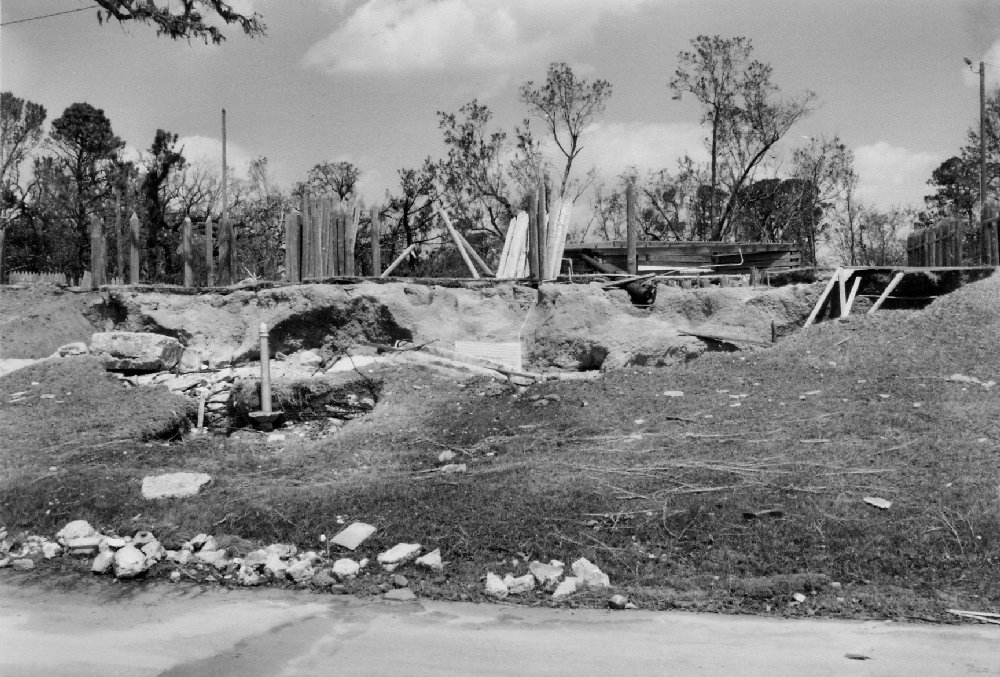
Fort Maurepas
(image made September 2005)
Post-Katrina
In the fall of 2005, the remains and debris of the battered and inundated Fort Maurepa replica were removed. The large, bastion timbers were saved. Mayor Connie M. Moran called for a public meeting at the Ocean Springs Community Center on the eve of April 27, 2006 to discuss the future of the site. Frank Burandt of Greg Cantrell Inc., landscape architects, of Kenner, Louisiana will present their design for the site. Mayor Moran said of the Fort Maurepas replica: "It was very user unfriendly and it was vandalized constantly, despite the installation of lighting and security cameras. We want this [new park] to be a place everyone can enjoy."(The Sun Herald, April 24, 2006, p. A3)
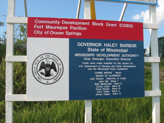
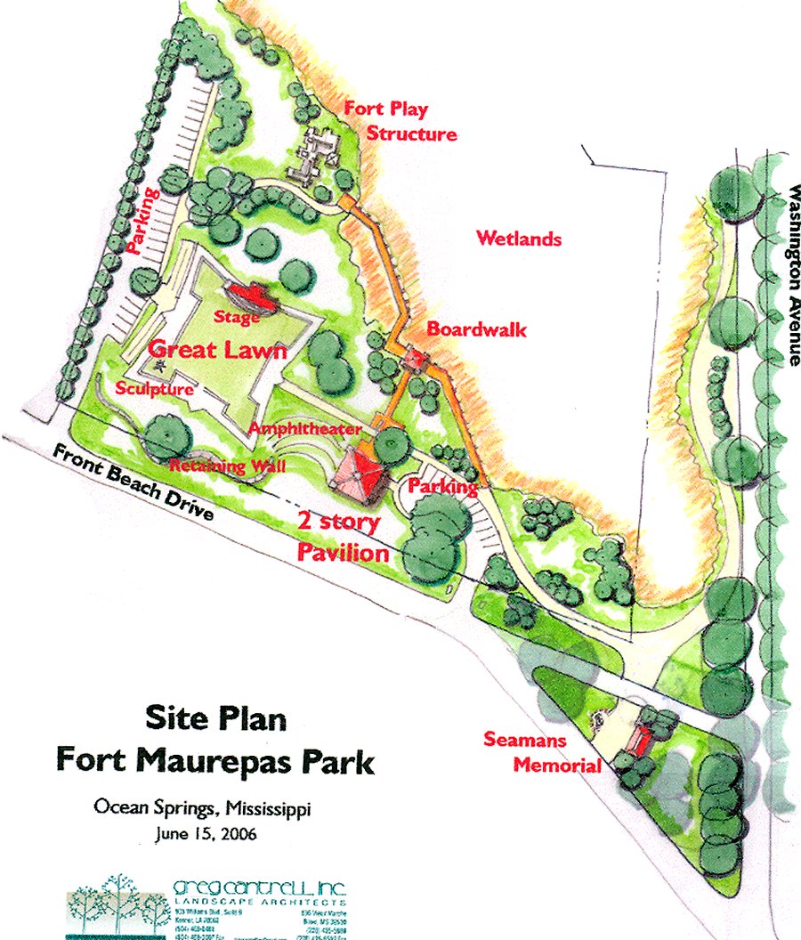
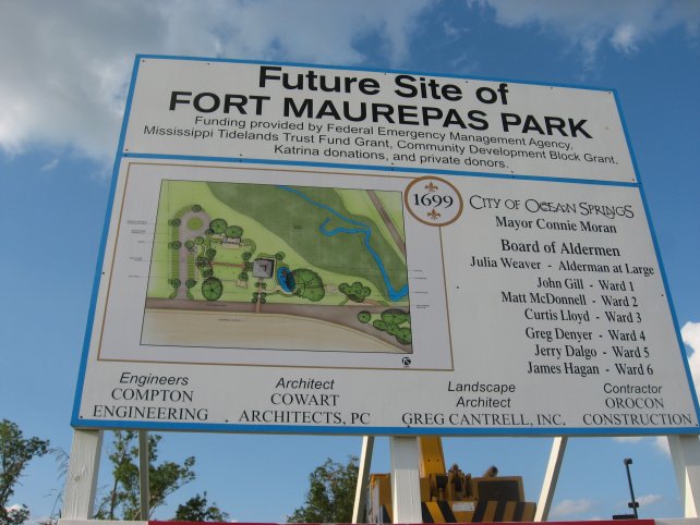
Fort Maurepas Park plan
Fort Maurepas Park
In mid-June 2006, about one hundred residents of Ward II, in which the Fort Maurepas replica sat for almost twenty-five years, overwhelmingly approved the preliminary plan of Frank Burandt, landscape architect, for a beach park on the beach front site situated between Washington and Jackson Avenues. Fort Maurepas Park will feature a Great Lawn outlined by a low brick wall, which in plan view replicates a Marshall Vauban (1633-1707) fortification, similar to that erected by Iberville's men in April 1699. Marshall Vauban served Louis XIV (1638-1715) of France as a military engineer. There will be a stage on the north side of the Great Lawn. The south side of the Great Lawn will be graced with statuary and historical markers commemorating the five centuries of local history. Other amenities of the Fort Maurepas Park will be a two-story pavilion with toilets, a playground for children, picnic tables, and a boardwalk on the southwest perimeter of the Fort Maurepas Nature Preserve.(The Ocean Springs Record, June 29, 2006, p. A1)
Eric Clark, Mississippi Secretary of State, revealed in a letter to Mayor Connie Marie Moran on July 24th, that the preliminary plans of the City of Ocean Springs to create a Fort Maurepas Park on the site of the Katrina damaged-destroyed Fort Maurepas replica meet with his approval and satisfy the requirement that Ocean Springs maintain the State donated property as an historic site. To quote from Mr. Clark: "The State conveyed the property to the City of Ocean Springs in 1991, and the deed requires the City to maintain the property as an official historic site. I have concluded that the plan described above honors that requirement and I am happy to give my approval. I wish you well with this project, and with your efforts to rebuild and improve your beautiful city."(The Ocean Springs Record, August 17, 2006, p. A10)
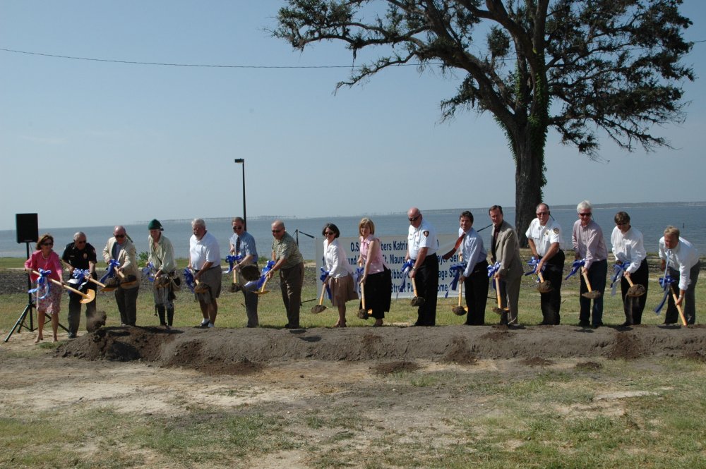
Breaking Ground- 29 August, 2006
[l-r: Alderman-at-Large Julia Weaver; Asst. Police Chief George Mulvaney; State Senator Tommy Moffett; Ray L. Bellande; Alderman Greg Denyer; Ken P'Pool, MDAH; John Gill, ?, Mayor Connie Marie Moran; Police Chief Kerry Belk; State Representative Henry Zuber; ?, Fire Chief Mark Hare; Frank Burandt of Greg Cantrell & Associates; ?; and Scott ? with Senator Trent Lott.
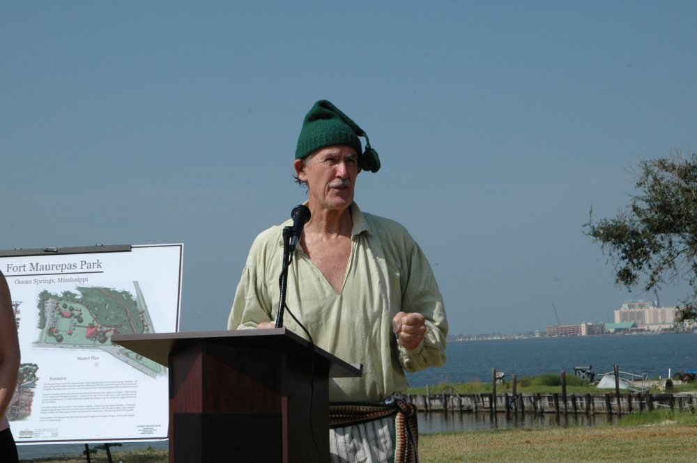
Ray L. Bellande, Local Historian
[images courtesy of Terry Dickson and The Ocean Springs Record]
Ground was broken for the Fort Maurepas Park on August 29th, 2006 at the site on Front Beach Drive with primarily local dignitaries and neighbors in attendance. Mayor Connie Moran opened the session with a welcoming statement to the small audience on the grounds. She was followed by Ray L. Bellande, local historian, who gave a brief history of the old Hansell-Edwards-Bland property on which the 1981 Fort Maurepas replica had stood until Katrina's wrath erased it last August 29th. Ken P' Pool from the Mississippi Department of Archives and History in Jackson,Mississippi closed the speech making with a review of the French Colonial history of the area and Ft. Maurepas' importance to the French effort in securing La Louisiane and establishing their future colony from here. Invited dignitaries then shoveled dirt to signify the commencement of the $1.3 million dollar project. Practically the entire cost of Fort Maurepas Park development will be derived from FEMA funds, the Katrina Benefit Fund owned by the City, and the Department of Natural Resources Tidelands Fund, thus placing no additional burden on taxpayers.(The Ocean Springs Record, August 31, 2006, p. A1)
Project in limbo?
In mid-October, the Board of Aldermen were informed by Adrienne Howell, City Clerk, that the anticipated $629,000 FEMA money intended for Fort Maurepas Park could be used ONLY to replace what was on the site, i.e. the 1981 fort replica. The Board believed that the FEMA grant was for the new park and voted not to spend any more money on the park project until it could be ascertained with certainty that funding was secure for the $1.3 million dollar project. Mayor Moran aspired that FEMA would accept the Fort Maurepas Park proposal as a qualified replacement for the destroyed Fort Maurepas replica.(The Ocean Springs Record, October 12, 2006, p. A1)
In January 2007, Mayor Moran related that an announcement of the historical site assessment of the Maurepas Park property would soon be released. This investigation was performed by contractors hired by the Department of Homeland Security for FEMA to ascertain in particular that no Native American artifacts on the proposed park site. By mid-January, the State Historical Preservation Office confirmed that an archeological survey of the park site, which included soil borings found nothing adverse to prevent the construction of Maurepas Park. The future of the project rests with financial assistance from FEMA, which is expected to pay 75 per cent of the estimated $1.3 million cost. A grant from the Department of Marine Resources [DMR] of $297,000 is anticipated to be given for parking, sidewalks, and for boardwalks to access the Fort Mauepas Nature Preserve. A private donation of $100,000 has been made for a playground for the park.(The Ocean Springs Record, January 11, 2007, p. 1 and January 18, 2007, p. A8)
Project alive and well
After the tenth public hearing on the proposed Fort Maurepas Park was held on July 2, 2007, the Board of Alderman elected to revise the current plan for the facility. Alderman Matt McDonnell of Ward II, the ward in which the proposed park will be located, proposed that the revisions include: use pervious materials for the thirty-two parking spaces; scale down the two-story pavilion; pull back the platforms in the marsh area; add low-level lighting; and maximize the green space. This proposal will be presented to the OS Historical Preservation Commission on July 12th and the Board of Mayor and Aldermen on July 17th.(The Sun Herald, July 9, 2007, p. A2)
Chester M. McPhearson Jr. Maurepas park pier
Bids for the Maurepas Park pier were opened July 3rd and contract was let construct a new, 650-foot pier with concrete pilings, lighting, a pavilion mid-way between the foot of pier and the T-head area at the head of the wharf. The modern structure will have running water and an area to clean fish. By mid-October 2008, the $722,000 water front structure was under construction with piles being set and a projected January 2009 completion date. The Department of Marine Resources will build an oyster reef at the termination of the pier to enhance fishing and rework the old reef off of the Katrina destroyed and abandoned Martin Avenue Community Pier to the west.(The Ocean Springs Record, July 10, 2008, p. A1)
The pier was completed in February 2009 by Brown and Mitchell Engineering of Gulfport. It was dedicated on March 21, 2009 and name in memory of Chester M. McPhearson Jr. (1924-2006), who served the City as its Mayor from 1981 to 1989 and Ward IV Alderman from 1953-1961.(The Ocean Springs Record, March 19, 2009, p. 4) .
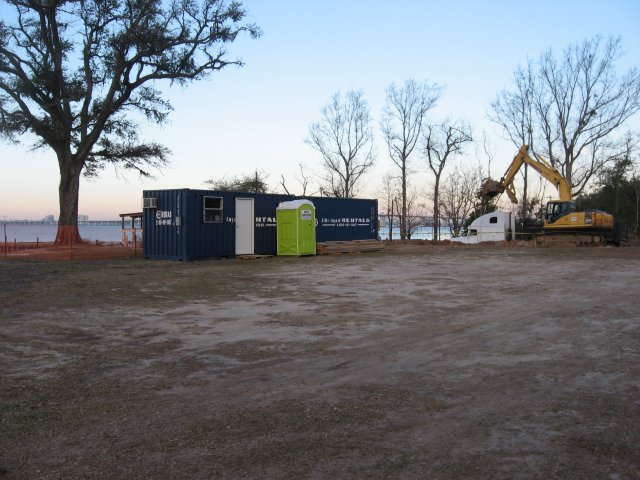
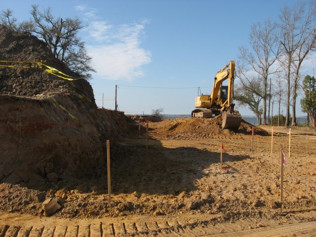
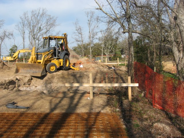
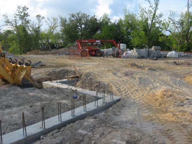
Construction started in early March 2009
Maurepas Park contracts awarded
On December 16, 2008, the City awarded Orocon Construction of Biloxi the contract to build Maurepas Park. The agreement excluded landscaping and irrigation from the nearly $2 million estimated cost for the bay-front recreational site, which is funded by FEMA, State tidelands money, Katrina donations, and private pecuniary resources.(The Sun Herald, December 17, 2008, p. A9)
On April 20, 2009, Marlene Hilton Moore, Canadian artist and sculptor, was awarded the contract to design and create a statue of Iberville for Maurepas Parc.
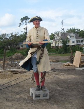
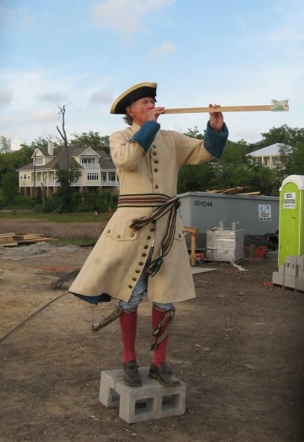
Ray L. Bellande modeling for Iberville statue
[image made by Mayor Connie Marie Moran on April 28, 2009]
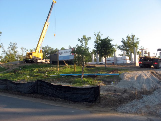
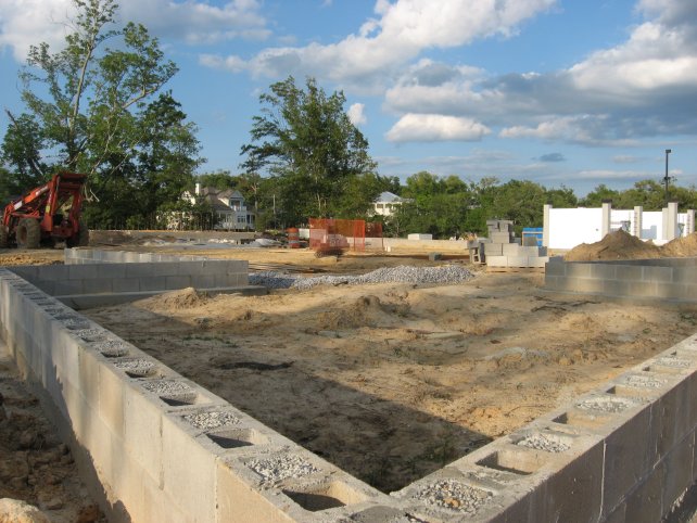
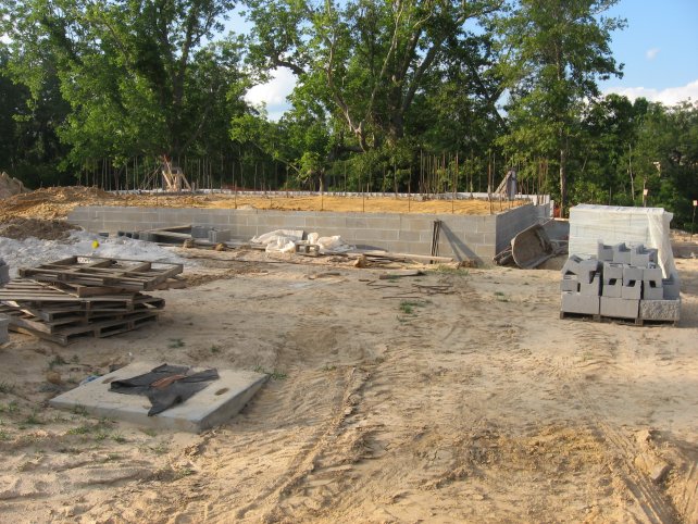

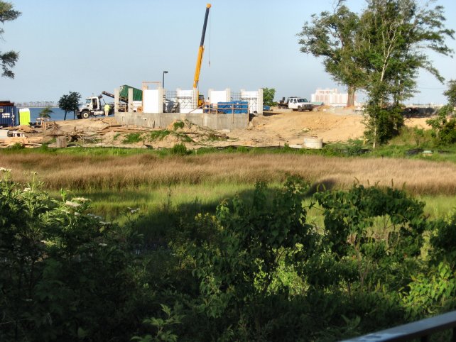
Construction site late May 2009
[images by Ray L. Bellande-May 28 and 29, 2009]
REFERENCES:
John H. Blitz, C. Baxter Mann and Ray L. Bellande, Mississippi Archaeology, "Fort Maurepas and Vieux Biloxi: Search and Research", Vol. 30, No. 1, June 1995, pp. 23-58.
Margaret Rose Caraway, " The Cornerstone of Old Fort Maurepas", Journal of Mississippi History, April 1951.
Volney J. Cissna, Jr.,"Reconstruction of Fort Maurepas", The Gulf Regional Planning Commission Report (Gulfport), 1973.
Charles L. Dufour, Ten Flags in The Wind: The Story of Louisiana, (Harper & Row: New York - 1967).
Jay Higginbotham, Fort Maurepas: The Birth of Louisiana, (Colonial Books: Mobile, Alabama-1968).
Elbert R. Hilliard, The Establishment of the Fort Maurepas Historical Site: A Report From the Board of Trustees of the Department of Archives and History- (1973).
Michael C. Krivor, Mississippi Archaeology, "Relocation and Evaluation of the Back Bay Biloxi Shipwreck Site 22 Ja542, Jackson County, Mississippi", Vol. 36, No. 2, 2001, pp. 101-128.
Richebourg Gaillard McWilliams, Iberville's Gulf Journals, (University of Alabama Press: University, Alabama -1981).
Mississippi Gulf Coast Yesterday & Today (1699-1939), "The Site of Fort de Maurepas", Federal Writers Project in Mississippi Works Progress Administration, (Gulfport Printing Company: Gulfport-1939), p. 91.
Dawson G. Phelps, Research Report of Fort de Maurepas, Mississippi, (US Department of The Interior, National Park Service-1939).
Dunbar Rowland, Old Biloxi: First Settlement in Mississippi, (Hederman Brothers: Jackson, Mississippi-1920).
C.E. Schmidt, Ocean Springs French Beachhead, (Lewis Printing Services: Pascagoula - 1972).
Charles Sullivan, The Mississippi Gulf Coast: Portrait of a People, (Windsor Publications: Northridge, California-1985).
WPA For Mississippi Historical Data-Jackson County,(State Wide Historical Project-1936-1937), 478 pages.
Journals
The Bay Press, "Ocean Springs breaks ground on new fort", September 1, 2006, p. 18.
The Daily Herald
The Daily Herald, "Story of Fort Maurerpas", February 21, 1921, p. 7.
The Daily Herald, "A song for the Coast [written by Laura A. Hinsdale (1855-1925) of Biloxi]", February 21, 1921, p. 7.
The Daily Herald, "Marker to designate site Ft. Maurepas", November 5, 1949, p. 2.
The Daily Herald, "April 8 Designated Fort Maurepas Day", April 5, 1951, p. 6.
The Daily Herald, "Historic Fort Maurepas site may be termed elusive", July 20, 1973.
The Daily Herald, "Fort Maurepas job to begin in 1980", October 3, 1979.
The Daily Herald, "Opening date set for Fort Maurepas bids", August 5, 1980.
The Daily Herald, "Fort Maurepas replica to be in Ocean Springs", September 12, 1980.
The Gulf Coast Times, "Celebration plans are perfected", March 4, 1949, p. 1.
The Gulf Coast Times, "Gov. Wright will attend celebration", March 11, 1949, p. 1.
The Gulf Coast Times, "Biloxi Bay area reaches 250 year mark with Confidence in the future", March 11, 1949, p. 7.
The Gulf Coast Times, "Fort Maurepas day to be observed in public school", April 5, 1951, p. 1.
The Gulf Coast Times, "Fort Maurepas program presented at public school", April 12, 1951, p. 1.
The Gulf Coast Times, "Our d'Iberville stone is gone; we know not where", July 5, 1951, p. 1.
The Jackson County Times
The Jackson County Times, "French Ambassador shown cornerstone of Empire Valley discovered in Ocean Springs", May 29, 1937, p. 1.
The Jackson County Times, "Old Coast Fort may become Shrine" June 26, 1937, p. 1.
The Mississippi Press
The Mississippi Press, "Friends of Fort Maurepas forms", June 14, 1992.
The Mississippi Press, "Fort foes to eat some crow", August 9, 1992.
The Mississippi Press, "First fort picnic: Fort Maurepas opens its wood doors to show needs for funds, completion", August 30, 1992.
The Mississippi Press, "Fort Maurepas is site of new Fireside Chats", July 7, 1003.
The Mississippi Press, "View living history event at Fort Maureas Oct. 8-10", October 3, 1993, p. 1-B.
The Mississippi Press, "Fort Maurepas comes alive in re-enactment ceremony", October 10, 1993, p. 1-A.
The Mississippi Press, "Fort Maurepas still lost, despite search", November 16, 1998, p. 1.
The Mississippi Press, "Groups join to reprint Fort Maurepas book", December 24, 1998.
The Mississippi Press, "French Colonial visitors tour Fort Maurepas", October 10, 1999, p. 8A.
The Mobile Press Register
The Mobile Register, "Fort Maurepas brought back to life", February 16, 1995.
The Ocean Springs News
The Ocean Springs News, "Iberville stone", October 21, 1965, p. 1.
The Ocean Springs News, "Biloxian says French built two settlements", August 9, 1967, p. 8.
The Ocean Springs Record
The Ocean Springs Record, "1699 Historical Committee receives State Charter", March 11, 1971, p. 1.
The Ocean Springs Record, "Maurepas replica shown", February 17, 1972, p. 1.
The Ocean Springs Record, "Fort Maurepas Scale Model", (photo, Claude E. Hooten, architect built model)-March 16, 1972, p. 1.
The Ocean Springs Record, "Progress seen for Fort Maurepas construction", February 8, 1973, pp. 1 and 2.
The Ocean Springs Record, "Cissna discusses Fort Maurepas", March 1, 1973, p. 1.
The Ocean Springs Record, "Reeks discusses Fort Maurepas", March 8, 1973, p. 6.
The Ocean Springs Record, "Archaeologists seek Ft. Maurepas proof", June 21, 1973, p. 1.
The Ocean Springs Record, "Search begins to find actual Ft. Maurepas site" , July 12, 1973, p. 3.
The Ocean Springs Record, "Archaeologists search for Fort", July 19, 1973, p. 1.
The Ocean Springs Record, "Maybe Maurepas?", July 26, 1973, p. 2.
The Ocean Springs Record, "Early articles support Ocean Springs as Maurepas site", August 9, 1973, p. 1.
The Ocean Springs Record, "Digging continues in search of Fort", August 16, 1973, p. 17.
The Ocean Springs Record, "The search continues", August 23, 1973, p. 2.
The Ocean Springs Record, "A clue", August 30, 1973, p. 3.
The Ocean Springs Record, "Maurepas included in Bicentennial", September 13, 1973, p.11.
The Ocean Springs Record, "Archaeologists continue search", September 27, 1973, pp. 1-2.
The Ocean Springs Record, "Galle presents interior view of Fort", March 28, 1974, p. 4.
The Ocean Springs Record, "Lane residents block Fort search", December 6, 1973, p. 1.
The Ocean Springs Record, "Senate approves Ft. Maurepas land purchase", February 27, 1975, p. 1.
The Ocean Springs Record, "Fort site selection meeting tonight", September 4. 1975, p. 1.
The Ocean Springs Record, "Building committee to consider land", September 11, 1975, p. 1.
The Ocean Springs Record, "Fort Maurepas site selection still undecided", October 16, 1975, p. 1.
The Ocean Springs Record, "Fort site could be decided by January 1", November 13, 1975, p. 1.
The Ocean Springs Record, "Aldermen take steps to conclude site purchase", January 15, 1976, p. 1.
The Ocean Springs Record, "Fort consultant's report gives bright prospects for Maurepas site", January 22, 1976, p. 1.
The Ocean Springs Record, "Favors Fort, opposes parking [letter to editor]", February 12, 1976, p. 4.
The Ocean Springs Record, "Fort is great idea, but at wrong location [letter to editor]", February 12, 1976, p. 4.
The Ocean Springs Record, "Fort 'ain't' my new neighbor yet [letter to editor]", February 12, 1976, p. 4.
The Ocean Springs Record, "Yacht Club agrees to sell property to State", February 19, 1976, p. 1.
The Ocean Springs Record, "1699 reaffirms Fort support", February 26, 1976, p. 1.
The Ocean Springs Record, "Deadline set for Fort proposal ballots", February 26, 1976, p. 1.
The Ocean Springs Record, "Clear survey majority favor Maurepas project", March 4, 1976, p. 1.
The Ocean Springs Record, "Fort Maurepas Land Purchased", March 11, 1976, p. 2.
The Ocean Springs Record, "Ft. Maurepas no Jamestown", (letter to editor)-March 11, 1976, p. 5.
The Ocean Springs Record, "More shots fired at Ft. Maurepas", April 22, 1976, p. 5.
The Ocean Springs Record, "New Marker [Sauvolle]", April 29, 1976, p. 5.
The Ocean Springs Record, "County behind Fort Maurepas project", October 21, 1976, p. 2.
The Ocean Springs Record, "Monies appropriated", March 31, 1977, p. 2.
The Ocean Springs Record, "Projects for Ocean Springs look doubtful", January 25, 1979, p. 1.
The Ocean Springs Record, "Fort Maurepas receives $300,000 in State funds", March 1, 1979, p. 1.
The Ocean Springs Record, "Fort Maurepas construction to begin soon", July 10, 1980. p. 1.
The Ocean Springs Record, "Bids for Fort Maurepas to be opened August 28th", August 7, 1980, p. 2.
The Ocean Springs Record, "Fort Maurepas to be opened in Jackson", September 9, 1980, p. 1.
The Ocean Springs Record, "Fort starts to take shape", January 22,1981, p. 1.
The Ocean Springs Record, "Funding delayed on Fort replica", July 16,1981, p. 1.
The Ocean Springs Record, "Maurepas replica 20% complete", December 17, 1981, p. 1.
The Ocean Springs Record, "Frenchman seeks Maurepas site", November 11, 1982, p. 1.
The Ocean Springs Record, "Maurepas funds frozen indefinitely", January 13, 1983, p. 1.
The Ocean Springs Record, "Fort Maurepas project still awaiting state commission's go-ahead", January 16, 1983, p. A 7.
The Ocean Springs Record, "Proof: d'Iberville's Colonists were permanent settlers of the Mississippi Gulf Coast", April 21, 1983, p. 1.
The Ocean Springs Record, "Fort Maurepas still depends on funds", March 21, 1985, p. 2.
The Ocean Springs Record, "Turned down by Park Service", August 28, 1986, p. 1.
The Ocean Springs Record, "The City contemplated leasing Fort Maurepas", May 17, 1990, p. 1.
The Ocean Springs Record, "City may get Fort Maurepas", February 21, 1991, p. 1.
The Ocean Springs Record, "City officially receives Fort Maurepas deed", July 25, 1991, p. 1.
The Ocean Springs Record, "Ours at last [photo]", July 25, 1991, p. 3.
The Ocean Springs Record, "Society seen as vehicle to move Maurepas along", July 23, 1992, p. 1.
The Ocean Springs Record, "Fort Society wants to know rules up front", August 13, 1992, p. 1.
The Ocean Springs Record, "Fort society, city discuss options for restoration of Maurepas", August 27, 1992, p. 1.
The Ocean Springs Record, "Fort Maurepas Society plans trip to Alabama", November 12, 1992, p. 8.
The Ocean Springs Record, "Fort Maurepas Society holds city picnic, outlines future activities", June 17, 1993.
The Ocean Springs Record, "History comes alive at Fort Maurepas", July 1, 1993.
The Ocean Springs Record, "Fort Maurepas Society to hear William Winter", August 5, 1993.
The Ocean Springs Record, "Living history weekend set at Fort Maurepas in October", August 5, 1993.
The Ocean Springs Record, "Ft. Maurepas Society announces events", August 12, 1993.
The Ocean Springs Record, "Former Governor to speak to Ft. Maurepas Society", August 12, 1993.
The Ocean Springs Record, "History come to life", October 14, 1993, p. 1.
The Ocean Springs Record, "City Oks Fort foundation", November 13, 1993, p. A1.
The Ocean Springs Record, "The Beach-New Beach Hotel: 1899-1921", May 19, 1994.
The Ocean Springs Record, "Visiting French teens say differences from home minor", August 18, 1994, p. 1.
The Ocean Springs Record, "Maurepas to go back in time this weekend", January 26, 1995.
The Ocean Springs Record, "Bastille Day finds French in fort", July 20, 1995, p. 1.
The Ocean Springs Record, "Society hosts guests", August 1, 1996, p. 10.
The Ocean Springs Record, "Reenacters stage living history", October 10, 1996, p. 1.
The Ocean Springs Record, "1699 soldiers to visit park [GINS], February 13, 1997, p. 5.
The Ocean Springs Record, "Fort Maurepas book re-issued for 300th", January 14, 1999, p. 1.
The Ocean Springs Record, "Quisconsin and Northwest Trading Company voyageurs arrive", February 11, 1999, p. 1.
The Ocean Springs Record, "Fort Salvage (two photos)", December 15, 2005, p. A1.
The Ocean Springs Gazette
The Ocean Springs Gazette, "Ending Maurepas [Park] rental a good call", October 24, 2013, p. 4.
The Sun Herald
The Sun Herald, "Fort's future murky", March 1, 1981.
The Sun Herald, "Funding for Coast projects approved", March 19, 1981.
The Sun Herald, "Fort Maurepas replication gets state approval", November 25, 1981.
The Sun Herald, "Fort Maurepas plans to be presented", July 20, 1982.
The Sun Herald, "Fort Maurepas replica should be considered for system (GINS)", March 23, 1986, p. A-2.
The Sun Herald, "Holding down the fort", August 22, 1992, p. D-1.
The Sun Herald, "Winters recounts tales of d’Iberville’s heroism", September 4, 1993, p. 1.
The Sun Herald, "They’re going to partake like its 1699", October 3, 1993, p. E-1.
The Sun Herald, Jackson County, "Vive la Maurepas", April 2, 1994, p. 1.
The Sun Herald, "Fort gets in on Carnival fun", February 4,1995.
The Sun Herald, "Building a case for Fort Maurepas Site", April 25?, pre 1997.
The Sun Herald, "Christmas Southern style", December 25, 1998, p. A-1.
The Sun Herald, "Fort Maurepas birthday party set", March 28, 1999, p. F-1.
The Sun Herald, "Ocean Springs, please shoot those cannons", April 4, 1999, p. E-1.
The Sun Herald, "Fort Maurepas group gets green light to develop plan", March 17, 2004, p. A-9
The Times-Picayune, "Biloxi Mardi Gras to hail old Fort Maurepas", December 19, 1956, Sec. III, p. 8.
Parc de Maurepas aka Fort Maurepas Park
The Bay Press, "Ocean Springs breaks ground on new fort", September 1, 2006, p. 18.
The Ocean Springs Record, "City mulls fort's future", December 22, 2005, p. A1.
The Ocean Springs Record, "Meek seeks new use for Fort's space", April 27, 2006, p. A1.
The Ocean Springs Record, "City listens to Fort Maurepas site ideas, options", May 4, 2006, p. A7.
The Ocean Springs Record, "Ward 2 residents back Fort site plan", June 29, 2006, p. A1.
The Ocean Springs Record, "City receives State OK on Fort Maurepas plans", August 17, 2006, p. A10.
The Ocean Springs Record, "City breaks ground on waterfront park", August 31, 2006, p. A1.
The Ocean Springs Record, "Fund question halts Maurepas", October 12, 2006, p. A1.
The Ocean Springs Record, "City hopes Maurepas funds near: FEMA awaiting historical assessment review", January 11, 2007, p. 1.
The Ocean Springs Record, "Maurepas plan clears State historical hurdle, FEMA next", January 18, 2007, p. A8.
The Ocean Springs Record, "Joint panel favors pier at Fort Maurepas", February 1, 2007, p. A1.
The Ocean Springs Record, "HPC discusses Fort Maurepas", January 31, 2008, p. A1.
The Ocean Springs Record, "New pier on beach and a fort to match", July 10, 2008, p. A1.
The Ocean Springs Record, "Construction set for Fort Maurepas", January 29, 2009, p. A4.
The Ocean Springs Record, "Beach party set for pier opening", March 19, 2009, p. 4.
The Ocean Springs Record, "d'Iberville will stand tall on beach", July 2, 2009, p. 12.
The Ocean Springs Record, "It is a real pirate's project", July 2, 2009, p. 12.
The Ocean Springs Gazette, "Fort Maurepas Park opens October", September 24, 2009, p. 16.
The Ocean Springs Gazette, "Front Beach takes on a view", September 30, 2009, p. 1.
The Sun Herald
The Sun Herald, "Fort Maurepas plan still in limbo", October 17, 2005, p. A-5.
The Sun Herald, "Fort Maurepas in Ocean Springs", November 28, 2005.
The Sun Herald, "Fort Maurepas up for debate", April 24, 2006, p. A3.
The Sun Herald, "Fort Maurepas site will be redesigned", April 24, 2006, p. A3.
The Sun Herald, "Alderman mull using Katrina funds for park revamp", July 9, 2007, p. A2.
The Sun Herald, "Fort Maurepas to get new life", December 17, 2007, p. A2.
The Sun Herald, "Pier Planned in Ocean Springs", October 12, 2008, p. A4.
The Sun Herald, "Park project awarded", December 17, 2008, p. A9.
The Sun Herald, "Fort Maurepas coming", December 29, 2008, p. A2.
-----------------------------------------------------------------------------------------------------
BILOXI BAY COLONIAL SHIPWRECKS: MYSTERY SHIPS?
The Sun Herald and The Mississippi Press in late January, 1997, announced that the Senate of Mississippi voted to appropriate $50,000 to the Mississippi Department of Archives and History. This money is to fund research to determine if a sunken 18th Century vessel, located in Jackson County waters just off the shoreline of Ocean Springs, belonged to the 1698-1699 fleet of Pierre Le Moyne d’Iberville. In addition, some of the money will be spent to estimate the cost to salvage the derelict, if warranted. (1,2)
This author has researched some of the locally available French Colonial period literature to determine what could be found concerning the sunken ship or ships in Biloxi Bay. The results of this survey are presented as follows:
By now we should all be familiar with the founding of Fort Maurepas at present day Ocean Springs by a French expeditionary force led by Pierre Le Moyne, Sieur d’Iberville (1661-1706). D’Iberville, A French Canadian naval officer, reconnoitered the eastern coast of the Gulf of Mexico during the fall and winter of 1698-1699, and established Fort Maurepas (1699-1702) in early April, 1699.
This French beachhead at present day Ocean Springs did not fulfill the aspiration of Jean-Baptiste Colbert (1619-1683), the Minister of Finance and Marine, under King Louis XIV (1643-1715). Colbert wanted a French port on the Mexican Gulf to harass Spanish territories providing mineral wealth to that nation. (3) Fort Maurepas, called Biloxey, did assert some Gallic authority to protect the 1682 French claim, "La Louisiane," of explorer René Robert Cavalier, Sieur de La Salle (1643-1687). This was especially evident when Jean-Baptiste Le Moyne, Sieur de Bienville (1680-1768) rejected the Carolina Galley, an English corvette from Carolina, carrying Huguenot colonists up the Mississippi River. The locale of the French denial of these colonists is known as English Turn. (4) In addition to providing a base and staging area for the regional exploration of "La Louisiane," Fort de La Boulaye (1700) and Fort Louis de La Louisiane (Old Mobile-1701) were founded from Biloxey.
By the end of the 17th Century, the European wars of Louis XIV were subsiding somewhat in Europe, and Louis Phelypeaux, Comte de Pontchartrain, now Minister of Marine, selected Canadian warrior and hero, Le Moyne d’Iberville, to locate the mouth of the Great River, missed by the ill-fated 1684 expedition of La Salle. Iberville was charged to fortify the Mississippi against Spanish and English incursions into the heart of North America. (5)
The 1698-1699 Gulf expeditionary force of d’Iberville to "La Louisiane" consisted of five ships, not three, as generally reported in our local journals. These vessels were: La Badina, a thirty-two gun royal frigate which served as the flagship of d’Iberville; Le Marin, a thirty-eight gun frigate commanded by La Rochefoucault de Surgeres; Le Francois, a fifty-eight gun frigate that convoyed the smaller vessels from saint-Dominique (Haiti) under the command of Marquis Joubert de Chateaumorant et de la Bastide; Le Precieuse, a royal traversier or freighter, and Le Voyager, a smaller traversier. (6)
It is known with a high degree of certitude that the three frigates of d’Iberville’s fleet were not able to sail without jeopardy into the Mississippi Sound because of their deep draft. They remained for the most part in or near the deep water Ship Island anchorage located on the northwest quadrant of the barrier island. Practically all of the coastal, estuarine, and river exploration by d’Iberville’s expeditionary force was conducted in the shallower draft craft, i.e., the traversiers, chaloupes, biscayennes, feloques, and birchbark canoes. Except for the traversiers, the other boats were carried aboard the larger frigates until needed. (7)
With this background, let us examine an event that transpired at Fort Maurepas in January, 1700. Historians, for the most part, generally agree that this French outpost was located at present day Ocean Springs on the Fort Point peninsula. In particular, the fort site is proposed north of the L&N railroad bridge on the Junius Poitevent (1837-1919) estate at present day 309 Lovers Lane. (8)
Commandant Monsier de Sauvois (c. 1671-1701), the French ensign who was appointed by d’Iberville to command the eighty odd men who remained at Fort Maurepas after his departure in May, 1699, reported in his journal on January 12, 1700, the following: Returning from the ships of M. d’Iberville, where I have been to receive the orders, we have noticed, before having put to land, our little traversier on fire, which was impossible to extinquish, being already too advanced, besides this, there were several barrels of powder, which, in a little time have had their usual effect. This accident has been caused by two bunglers who having been to work on board, have left there a lighted fuse which has occasioned this loss; I am inconsolable, because of the need we had of it. (9)
Inhabitants of Ocean Springs were aware of a sunken vessel in Biloxi Bay as early as the 1850s. Circa 1933, Josephine Bowen Kettler (1845-1933+), a resident of Lyman, but indigenous to the Ocean Springs area where her father, the Reverend P.P. Bowen (1799-1881), was an early Baptist minister and pioneer citizen of the village, visited the son of Junius Poitevent, Schuyler Poitevent (1875-1936), at his home, Bay View. Fort Maurepas, as previously mentioned, is believed to have been formerly located on the Poitevent Estate. Mr. Schuyler Poitevent lived quietly on the Bay of Biloxi with his small family. Here he wrote fiction and historical books, collected artifacts, and was a serious student of Colonial history. Mrs. Kettler during her visit related to Poitevent her recollections of the small village of Ocean Springs where she was reared. Germane to this report is the following commentary from Mrs. Kettler: There was a place where we children used to go pick blackberries. It was a sort of clearing where there had once been an old fort and there were lots of old 2bricks scattered about, and cannon balls, and the blackberry vines grew as high as this. They had just the biggest sort of berries. They called it in those days, "Spanish Camp."
At this point, Scullery Poitevent interrupts Mrs. Kettler and informs her that his estate is sometimes called the "Spanish Camp." Mrs. Kettler continues: So this is the "Old Spanish Camp, is it? Well, it has changed, for in those days there were no homes here; we children when we could come to pick berries would sometimes wade on the beach, and there was an old cannon sticking breech up out there in the Bay and when the tide was out and the water low we could see it and we used to chuck at it and throw sticks and shells at it; and I guess it is out there yet. (10)
Although she was obviously unaware of preceding events that had occurred at Ocean Springs during her long absence, Mrs. Kettler’s guess about the shipwreck had been affirmed in August, 1892, when a "mystery ship" was come upon by a young oysterman, Henri Eugene Tiblier, Jr. (1866-1936), in the Bay of Biloxi, on an oyster reef known locally as "the rock pile." The "rock pile" was located about a quarter mile in a southwest direction from the residence of retired railroad agent, Alonzo Sheldon (1832-1904). The old Sheldon home, once called "The Cedars," is now known as "Conamore. The Connor-Joachim family happily resides here today at 317-319 Lovers Lane. Coincidentally, "Conamore" is located just south of the Poitevent place. (11)
Donald L. "Pat" Connor (1912-1982), and his wife, Ethelyn MacKenzie Schaffner Connor (1918-2013), have long been an integral part of the efforts to preserve the history, culture, and environment of Ocean Springs. In this manner, their names are associated with the following: Fort Maurepas Society, Jackson County Tercentennial Commission, Ocean Springs Centennial Commission, Ocean Springs Genealogical Society, 1699 Historical Committee, and Societe Des Arbres.
In July, 1973, the Connors, unlike many residents on Lovers Lane, allowed archaeologists from the Mississippi Department of Archives and History to conduct excavations at Conamore. Trenching was done in an attempt to locate the remains of Fort Maurepas. Although not successful in finding the fort, the archaeological survey did reveal a large feature. Radio carbon dating of charred posts from the structure indicated it to be 1755 AD, (plus or minus 55 years) in age. Several faience sherds, gun flints, and a colonial brick were discovered on the Connor property. (12) In addition, Mrs. Ethelyn Connor has three seven pound cannon balls that were found by her sons on the beach in front of her home. (13)
Shortly after the Tiblier find, The Pascagoula Democrat-Star, on September 23, 1892, reported the discovery of the sunken vessel as "A Mysterious Find." A summary of the where and what of that salvage operation, which was conducted by the Henri Tibler, Sr. (1841-1930) family on the submerged vessels follows: The "rock pile," a good oyster reef in Biloxi Bay about a quarter mile in a southwest direction from the residence of Colonel Sheldon. Water depth twelve feet at high tide.
SHIP
The ship was described as approximately 55 feet in length and probably 10 feet wide. Made of oak and mahogany in a fair state of preservation. No nails were found as the vessel was built with wooden pins. Bolts used in iron work made of copper.
OBJECTS FOUND
-
Non-indigenous stones and boulders which were probably ballasts for the vessel.
-
Some firm brick—8 inches long, 4 inches wide, and 1 3/8 inches thick.
-
A large number of iron braces—12 feet long, 2 ¼ inches wide, and ½ inch thick.
-
A 9 inch diameter sheave with a one inch groove and block 12 inches, also a small one. Both made from different wood used at the time. A 12 inch block eye and others about half this size. These indicate a vessel of large tonnage.
-
Four cannons:
a) One 6 foot long bore with a 3 ½ inch muzzle in fair condition. "H.E. or F.O.S." are discernible and located about one foot from the vent. A small amount of powder was fired from the gun by the fisherman with no problem.
b) One 7 foot long bore with part of the hard wood, gun carriage attached to the right side.*
c) One 4 feet in length with a 2 ½ inch bore badly eroded by rust.
d) Cannon balls: a 2 inch, 2 ½ inch, and 3 inch cannon ball were found.
e) Muskets: Several muskets capable of firing a one ounce ball were found. Their locks were described as very old fashioned, the nipple and vent perfect.
f) Gunpowder: A quantity of gunpowder in chunks located which retained its original odor.
1. Miscellaneous objects:
a) a water cask bung stopper made of several thicknesses of woolen cloth.
b) scabbard of an officer’s sword which retained much of its original shape. (14)
This same story also titled, "A Mystery Find," appeared in The Biloxi Herald on September 24, 1892, on the front page. A follow up account appeared in this Biloxi journal on October 8, 1892, which narrated the following: Last Tuesday (October 3rd) a large crowd went over on the Agnes M to see the cannons, rocks and other curiosities that have been fished up at Ocean Springs. (15)
The schooner, Maggie, owned by Jose Suarez (1840-1912), a Spanish immigrant residing in the Bayou Porto area, served as the salvage vessel for the Tiblier operation on the "rock pile." Suarez, known as Pep, made medicines from the local herbs and sold them to his neighbors after he proved to himself that they were effective. (16)
*Today the muzzle of the former seven foot cannon is gone, probably rusted away. The tube now measures 5 feet and 2 inches.
The Maggie was built in New Orleans in 1878, by Sydney J. Anderson (1867-1917), an entrepreneur active in commerce at Vancleave and Ocean Springs. She was a coastal trading schooner of the 10.03 net tons. The dimensions of the Maggie were: Length--41 feet, beam--16.1 feet, and depth—3.8 feet. Captain Suarez purchased the vessel from Anderson in August, 1888, for $425. (17)
Before 1931, Laville Bremer, a writer from New Orleans, came to Biloxi and wrote a small treatise, Biloxi Historical Sketch. One of his short stories, "The Iberville Cannon" corroborates the 1892 newspaper account, "A Mysterious Find." It appears from this narrative that Bremer may have interviewed Captain Tiblier before his demise in 1930. He wrote concerning the Colonial wreck off the Fort Point peninsula: Mr. Tiblier decided to investigate the remaining wreck. For nearly two hundred years she had lain unmolested, pointing an accusing bow in the direction from which the hurricane had come. He got together an outfit and proceeded to stake out her dimensions by soundings She proved to be about sixty-five feet in length by twenty in width, and forty feet or so behind her lay a small lighter such as was used in those days. (18)
Unfortunately, very little of the salvaged objects from the sunken ship remain today. The most visible are the four, oxidizing cannons embedded in concrete at the Villa Santa Maria on East Beach Boulevard at Bilozi. They were placed here before 1931, when the Biloxi Community House stood on this site.
Martha Tiblier Eleuterius (1919-2001) of Biloxi related anecdotes told to her by Numa I. Tiblier (1886-1965) her father, and Henri Eugene "TuTu" Tiblier, Sr., her grandfather, concerning the sunken vessel. She relates that Captain Martin Van Buren Green (1842-1929) of Biloxi would sail his large catboat with tourists aboard to the Tiblier cottage on the Bay of Biloxi west of Bayou Porto. Captain Tiblier gave away most of the smaller artifacts, primarily French bricks, swords, and cannon balls, which had been brought from beneath the murky bay waters by his sons, Albert Tiblier (1869-1953) and Vital Tiblier (1875-1932), to these strangers who were naturally enamored with them. She does not remember the disposition of the yard arm brought from the sunken craft.
Mrs. Eleuterius also tells that TuTu Tiblier would fire the cannons in his yard using the salvaged 18th Century gunpowder. She remembers a tale about another derelict vessel submerged in Biloxi Bay off Grand Bayou, north of Deer Island. Several bronze cannons are believed to have been found by a Captain Fountain and sold at New Orleans for scrap metal. In regard to the "rock pile" derelict, Martha T. Eleuterius says that the only other person to her knowledge to dive on the wreck was Joe Agregaard, who brought up only wood in his 1950s attempt. (19)
Another interesting facet of this story is the cannon in the yard of the Poitevent home on the Fort Point peninsula. It is generally believed that this small naval artillery gun, whose tube is 4 feet and 3 inches long, and is located in the small garden in the rear of the Junius Poitevent estate at 321 Lovers Lane, was also taken off the "rock pile." A collection of twelve cannon balls, ranging in diameter from 3 inches to 4 ½ inches are set in a cement block adjacent to the cannon. (20)
Anecdotal family history states that the weapon was set up in the Poitevent garden in 1892, and fired in celebration of the results of the 1896 presidential election. The resulting explosion caused windows in the Poitevent home to shatter. They were replaced by new panes brought from New Orleans. (21)
The theory most often proposed by historians as to the origin of the sunken vessel on the "rock pile" in Biloxi Bay is that it was a victim of the Hurricane of September, 1722. Jean-Baptiste Bernard de la Harpe, a French soldier who served in the Louisiana Colony from1718 until 1723, kept a journal during his tenure here. He wrote on September 11, 1722: A hurricane began in the morning which lasted until the 16th. The winds came from the southeast passing to the south and then to the southwest. The hurricane caused the destruction of beans, corn and more than 8,000 quarts of rice ready to be harvested. It destroyed most of the houses in New Orleans with the exception of a warehouse built by M. Pauger. The warehouse of Fort Louis (present day Biloxi) containing a large quantity of supplies, was overturned to the great satisfaction of its keepers. The accident freed them from rendering their accounts.
The Espiduel, three freighters, and almost all of the boats, launches, and piroques perished. The Neptuneand the Santo-Cristo, which had been repaired according to the orders of the commissioners, were entirely put out of service. A large supply of artillery, lead, and meats which had been for a long time in a pincre, were lost near old Biloxi (Ocean Springs). The French had neglected to unload the ship for more than a year. They were also worried about the three ships anchored at Ship Island and the Dromadaire, which had been sent to New Orleans loaded with a supply of pine wood, which would have cost the company more than 100,000 livres. (22)
Bremer (1931) suggests that the "terrible equinoctial storm" of 1723 (sic) as the cause of the sinking of the "rock pile" boat. He obviously acquired anecdotal history at Biloxi when describing the disposition of several vessels believed to have been victims of the 1722 storm. Bremer wrote: The largest of the vessels that went down lay in the sound between Deer Island and what is now Ocean Springs. The smallest lay near the mouth of Bayou Bosard* on the east shore of the Bay, and the one from which these cannons were removed lay farther in, northeast from the Louisville and Nashville railroad bridge about sixteen hundred feet from shore in a fathom of water. Salvage work had been attempted on the larger of the three which yielded some eight foot iron cannons, a small bronze cannon, pig lead and little else. The smallest had long since disappeared and become only a memory among the older people. It had been made of mahogany and its valuable boards were gradually made use of. (23)
*The location of Bayou Bosard is uncertain to the author as this nomenclature is not in current use. The small bayou that was dredged and made into the Ocean Springs small craft harbor has been referred to in the past as: Bayou Bauzage and Mill Dam Bayou.
Prior to 1997 MDAH sponsored survey of the 'rock pile' wreck in Biloxi Bay north of the CSX Railroad bridge off Lovers Lane, in December, 1972, Gulf South Research Institute of Baton Rouge, Louisiana, under contract to the Mississippi Department of Archives and History, ran a magnetometer survey across a two-acre, rectangular site recommended by Dr. Charles K. Eleuterius (1940-2003), a physical oceanographer, at the Gulf Coast Research Laboratory in Ocean Springs. Dr. Eleuterius is the great grandson of Captain H. Eugene Tiblier who salvaged artifacts from the wreck in 1892. Jack C. Hudson, Historical Site Archeologist, with the consulting firm, reported to Elbert R. Hillard, Director of the Mississippi Department of Archieves and History, that a plot of the magnetometer survey data demonstrated many areas of high intensity readings in the northwest quadrant of the survey area. This is the location that Dr. Eleuterius predicted where the sunken vessel would lie, prior to the geophysical survey. (24)
Hudson (1973) speculated that if the sunken vessel in Biloxi Bay was preserved in the silt as anticipated, it would be to his knowledge, "the earliest intact colonial ship extant." This hope no longer exists for Mississippi as in late January, 1977, archaeologists of the Texas Historical Commission recovered two 800 pound bronze cannons from La Belle in Matagorda Bay on the lower Texas coast. The weapons bear the crests of Louis XIV and Le Comte de Vermandois, Admiral of France from 1669-1683. (25)
La Belle, a small six-gun frigate of 50 foot length, was part of LaSalle’s ill-fated 1684 expedition to locate the Gulf outlet of the Mississippi River and fortify it. This vessel appears to be similar in size and style to the one on the "rock pile" off Ocean Springs. The Texas marine excavation cost over $1 million. A twin-walled, oval cofferdam was built to investigate La Belle. The protective structure let workers pump out the 12 foot deep water which overlies the sunken vessel. (26)
From the current historical and anecdotal information available, it would appear that there are several small-medium sized vessels of the early Louisiana French Colonial Period (1699-1724) located in the mud and silt-laden bottom of Biloxi Bay. Were these "mystery ships" associated with the 1698-1699 expeditionary flotilla of d’Iberville, victims of the 1722 Hurricane, or neither? Stay tuned, someday we should find out what $50,000 worth of taxpayers’ money will buy from the research and scientific efforts of the Mississippi Department of Archives and History.
REFERENCES
1. Sun Herald, "Senate votes $50,000 for ship," January 27, 1997, p. 1-C.
2. Mississippi Press, "Historians hope to link sunken boat to d’Iberville," January 27, 1997, p. 8-A.
3. Dunbar Rowland, The History of Mississippi, The Heart of the South, Volume 1, (S.J. Clarke Publishing Company: Chicago-Jackson: 1925) , p. 126.
4. Charles J. Dufour, Ten Flags in the Wind, (Harper & Row: New York-1967) pp. 48-49.
5. Ibid., p. 35.
6. Carl A Brasseaux, A Comparative View of FrenchLouisiana, 1699 and 1762, The Journals of Pierre Le Moyne d’Iberville and Jean-Jacques-Blaise d’Abbadie, (Center For Louisiana Studies, USL: Lafayette, Louisiana-1981) pp. 5-7.
7. Mississippi Coast History & Genealogical Society, "Iberville’s Boats", Volume 32, NO. 1, PP. 5-6.
8. Peter J. Hamilton, Colonial Mobile, (reprint Heritage Books Inc., :Bowie, Maryland-1991), pp. 45-46.
9. Jay Higginbotham, The Journal of Sauvole, (Colonial Books: Mobile, Alabama), p. 41.
10. Schuyler Poitevent, Broken Pot, (unpublished manuscript: Mississippi Department of Archives & History, Poitevent Collection), Chapter 7- "Biloxi Bay."
11. Ray L. Bellande, Ocean Springs, The Way We Were: 1900-1950, (Ocean Springs Rotary Club: Ocean Springs, Mississippi-1996, p. 93.
12. Elbert R. Hillliard, "The Establishment of the Fort Maurepas Historical Site: A Report From The Board of Trustees of the Department of Archives and History," January, 1974, pp. 6-7.
13. Personal Communication: Ethelyn Connor to Ray L. Bellande-July, 1992.
14. Pascagoula Democrat Star. "A Mysterious Find," September 23, 1892, p.2, c. 3.
Biloxi Herald, "Local Happenings," October 8, 1892, p.4, c. 4.
16. Personal Communication : Martha T. Eleuterius to Ray L. Bellande-February, 1997.
17. Hancock County, Mississippi Land Deed Book D, pp. 273-276.
18. Laville Bremer, Biloxi Historical Sketch, (General Printing Company: New Orleans-1931), p. 34.
19. Personal Communication: Martha T. Eleuterius to Ray L. Bellande-February, 1997.
20. Personal Observation: Measurements and sketches made by Ray L. Bellande-February, 1997.
21. Daily Herald, "A Developed Beautiful Garden," May 5, 1970, p. 15.
22. Jean-Baptiste Bernard de la Harpe, The Historic Journal of the Establishment of the French in Louisiana, (University of Southwestern Louisiana: 1971, pp. 214-215.
23. Laville Bremer, Biloxi Historical Sketch, (General Printing Company: New Orleans-1931, p. 34.
24. Gulf South Research Institute, "Field Report and Magnetometer Survey Analysis-Biloxi Bay, Mississippi," January 12, 1973. 3.
25. Ibid., p.2
26. Sun Herald, "Bronze cannons retrieved from LaSalle shipwreck,’ February 2, 1997, p. A-2.
Others
The Daily Herald, "Vessel that may have belonged to D'Iberville rests on bottom of Back Bay of Biloxi---cannon from vessel decay in Biloxi yard", March 4, 1922, p. 8.
Ray L. Bellande
PO Box 617
Ocean Springs,
MS 39566-0617
228-424-6041
February 9, 1997.
-----------------------------------------------------------------------------------------
VIEUX BILOXY and ENVIRONS: 1720-1721
Until Dr. Val Husley recently presented me with "The Voyage to Louisiana (1720-1724) of Franquet de Chaville", the only description of French Colonial Ocean Springs that I had read was in Richebourg Gaillard McWilliam's, Iberville's Gulf Journals (1981). Charles Franquet de Chaville, a French engineer, was assigned to Louisiana with Adrian de Pauger (d. 1726) and Chevalier de Boispinel (d.1723) to work under Chief Engineer of the Company of the Indies, Pierre Leblond de La Tour (d. 1723).
Leblond de La Tour drew the plans for Vieux Biloxy (Ocean Springs), Fort Louis at Nouveau Biloxy (Biloxi), and Nouvelle Orleans (New Orleans). Fort Louis, which was located west of the Biloxi Lighthouse, was never completed as the Louisiana capital was moved to New Orleans in 1722. Monsieur de Chaville arrived in the Louisiana Colony first at Ile Dauphine (Dauphine Island) aboard the Dromadaire. He then went to the natural harbor at Isle aux Vaisseau (Ship Island) before disembarking at Vieux Biloxy (Ocean Springs) in December 1720.
Franquet de Chaville like his fellow engineers eventually went to New Orleans. He assisted Ignace Francois Broutin (d. 1751), who in 1745, would design the second Ursuline Convent, on several projects. The most noted was the "Plan of the Chapitoulas" (1724). It was a map of the Ste. Reine Concession up river from colonial New Orleans. Noted architect and architectural historian of New Orleans, Samuel Wilson, stated the following concerning the draftsmanship and coloring of the Broutin-de Chaville map of the Chapitoulas: It seems almost incredible that such a large and fine drawing could be made in the wilderness that was Louisiana in 1724 but other drawings of comparable quality were produced by Leblond de La Tour and his associates from the time they arrived in Biloxi in December 1720. Their draftsmanship was of the same high quality that marked the work of the architects and engineers of early eighteenth-century France, and Broutin, by this "plan of the Chapitoulas", proved himself to be one of the best.
The following was generously translated by Madame Eileen Za of Ocean Springs and is the Franquet de Chaville description of Ocean Springs and the Mississippi Gulf Coast in late 1720 and early 1721.
Old Biloxi is situated at the back of a bay surrounded by marsh. The land that we settled on (occupied) is a plateau, stretching for about 2400 feet. It was the only place we could see without any trees. Those who had recently arrived from France had built cabins for themselves there. The only house, that is to say a building or barracks worthy of the name, that was to be seen was that occupied by the Directors. All others were built in a style I have described later.
As far as age goes, this post was the oldest, according to the Commander, established at the time they discovered the mouth of the river in 1702. It was occupied a second time after Dauphin Island was abandoned. Hunting and fishing are abundantly rewarded, deer among others, is very good. It is certainly the best eating when cooked on a spit. The fish which is caught in the bay is called red fish and is the very best. It is larger than a large carp and its flesh is very firm. The scales are like those of a carp except that they are red. The Commander and the Directors were always well supplied with red fish for their table. Since they felt honored to invite newly arrived officers, I ate there almost the whole time during my stay.
Up until now, I have not touched on what happened, but now will try to fulfill my mission. After having recovered from the fatigue of the journey, I was ordered to report to New Biloxi, which lies opposite the anchorage of Ship Island. Everyone sent from France debarked there to rest, while waiting for boats to be built to take them to their destinations.
We started work by cutting down a large number of trees to build barracks. Each one made his own. After each person had built his own shelter, we began work on lodgings for the Directors. A warehouse was built to hold the goods, which had been unloaded on the sand. This work was cheerfully begun. All the workers inspired by the same feelings, gladly undertook to build the foundations of a new town. In truth, everything needed to encourage them in this work was provided. Bread and wine were doled out in abundance. The weather was calm, neither too hot nor too cold, just right. Everything was fine at the beginning. But this happy period did not last. The heat was excessive Boats did not arrive. Food was cut back for the workers. Foolishly, no more was distributed to them. They fell ill. Work stopped. Each man was to busy looking after himself, hunting and fishing for food. To all these troubles were added the greatest of all-homesick. In less than six months our work force was halved. Colonies that had been intended to house other concessions fared no better. Most of the good workers died, which meant they could not make the necessary voyage to the site indicated by the Company since they had already eaten most of their food. The only thing they could do was to wait on the river bank for new help in travelling further on.
During this period of distress, we received no news of any other ship, and it seemed as though one would never come, that we had been completely forgotten, which doubled our worries, and caused many me to desert and flee from this unhappy Colony, going to live among the Spanish, who offered them asylum. This annoying predicament led us all to think differently depending on how much interest we had in the success or failure of the enterprise. But we were united on one point-we expected nothing good.
The chief engineer unburdened himself on the subject of the Company. Rather than find something that would reward him for all his work, he felt, sadly, only the uselessness of the endeavor, and the final disgrace, he had nothing to work with. He had been told in France that he would have a heap of material necessary for the proposed projects. Instead of the expected abundance, he saw only a frightful lack of just about everything. Time to him to short to ensure the definite establishing a Colony. He calculated the enormous expense already incurred, which was totally useless, and the further expense, which would be necessary. He was shocked (horrified) by the amount, especially as everything at this point was not resolved, not even the final decision on the location of the post, whose final situation was still not assured since the advantages of this particular site had not yet been combined with those of the whole coast. He was slow, as were we all, to recognize this fact. The memoranda on these points could not satisfy us. It was easy to see the spirit that dictated them: self pride combined with a vested interest played a large part, and truth was nowhere to be seen.
To commit oneself to this project any longer could have meticulous consequences. We were therefore sent off to make a meticulous visit to the coast. One of my comrades was ordered to sail down the Mississippi and carefully observe the mouth of the river. You will find this description later.
I was sent to Ship Island and Cat Island to map them both. I left in a small boat with six sailors and nine workmen to help me in my operations. I was provided with food for 15 days, bacon, biscuits, and brandy. It was August. Judge for yourself whether we needed anything to keep us warm! We could almost burn up like matches.
First I went to Ship Island. I made a map and took soundings in the anchorage. Here is a brief description.
Description of Ship Island
This island is situated on the same latitude as Dauphin Island, lying the same distance from shore and in the same direction. The two are separated by another island, called Horn Island. The soil of the three islands is similar, not good for cultivating food.
Ship Island is shaped like a fichu having two points, each about a league long with no trees. The center has a few pine trees and some small oaks, for about a league. The whole island is only three leagues long by one-half league wide. There is a pond 5500 feet across which connects with the sea. Monsieur d'Iberville, captain of the King's fleet, named it Ship Island, when he moored there when he discovered the mouth of the Mississippi River.
The harbor is in the bay formed by the west and north points of the island. It can hold a goodly number of ships moored in 20 feet of water, with sandy bottom, sheltered from the sea and winds by the island, having only to fear those winds off the land (from the north). But the over all picture is good. Besides the tide there does not rise very high. There is a sand bank which lies ENE and WSW about 5000 feet in size. Water depth there is about thirteen feet, with a base of hard grey sand. To avoid this bank and arrive at a good mooring place, this is the route to take: When passing the western point of the island, keep at a distance of about 1 1/2 cables, where the water is about 30-40 feet deep. Sail along the length of the island, taking care to keep a little distance from shore because of the strips of land which stick out more as they near the back of the bay. When you are a quarter of a league from the trees, go NNE to moor. As far as safety from enemies is concerned, it would be difficult to hide the ships.
Fish is plentiful and can easily be caught in a net. We caught many that resembled the fish along the French coast.
When I had finished all that I had been ordered to do, I left to do the same at Cat Island, which is about 2 leagues distant. Bad weather prevented me from examining it exactly as I would have liked, as it was struck by its poor location. It is riddled with marshes, which connect to the sea, and make its use impracticable. The whole time that I was there strong winds led me to find it very disagreeable. Food was getting short and we were reduced to eating wild cats and some oysters, which abound along the coast.
Fatigue was a major problem for all of us, but especially me. I suffered on all sides, sleeping on the sand, and eating bad food did not suit my temperament at all, and I paid dearly for it after this tour of duty. I was very sick. My comrade arrived some time after his trip to the mouth of the river with a detailed map of the various practicable openings, which had been unknown until then for ordinary Company vessels!
The Commander in Chief who knew this began to tell everyone not to believe it as it was just an idea of the engineer. Why he did this we did not know. The chief engineer even though he got along well with my comrade, the engineer, did not know what to make of this contradiction, and the denials that he received daily on every issue, and he had a hard time trying to discover the truth. He had been refused, on our arrival, admission to council meetings, which he blamed on the Directors. He was not allowed to enjoy the same privileges that they enjoyed by virtue of the new orders contradictory to those he carried. He realized that the man's maneuvers were completely sincere which led to such inner unhappiness that eventually it killed him. Still, he followed the advice given him and worked with the Biloxi post, less out of confidence in this advice, than to pass time while waiting for a reply from France to the memo he had sent regarding the situation at this post and also regarding the mouth of the river.
The Franquet de Chaville report on his travels and work in French Colonial Louisiana is over forty pages in length. This excerpt represents eight pages. de Chaville left New Olreans and returned to La Rochelle, France in 1724. By 1764, Franquet de Chaville carried the title, Chief Engineer and Director of Fortifications. In 1765, he was named Director of Engineers.
Merci beaucoup a' Madame Eileen Za for her excellent translation of the French text.
REFERENCES:
Jean M. Farnsworth and Ann M. Masson, The Architecture of Colonial Louisiana: Collected Essays of Samuel Wilson, Jr. F.A.I.A., (University of SW Louisiana-1987), p. 24, p. 224-225,
Journal de la Societe Des Americanistes De Paris, "Le Voyage En Louisiane de Franquet de Chaville (1720-1724)", pp. 20-27.
Personal Communication:
Dr. Val Husley
Eileen Za
REFERENCES:
BOOKS
Carl Brasseaux, A Comparative View of Frenck Louisiana, 1699-1762: The Journals of Pierre Le Moyne d'Iberville and Jean-Jacques-Blaise d'Abbadie, (The Center For Louisiana Studies @ USL: Lafayette, Louisiana-1979), 159 pages.
Laville Bremer, Biloxi Historical Sketch, (General Printing Company: New Orleans-1931), 42 pages.Glenn R. Conrad, Immigration and War, Louisiana: 1718-1721, (USL: Lafayette, Louisiana-1970), 55 pages.
Glenn R. Conrad, Historical Journal of the Settlement of the French in Louisiana, (USL: Lafayette, Louisiana-1971), 272 pages.
Patricia K. Galloway, La Salle and His Legacy, (University Press: Jackson, Mississippi-1982), 260 pages.
Jay Higginbotham, Fort Maurepas: The Birth of Louisiana, (Colonial Books: Mobile-1968), 93 pages.
----------------, The Journal of Sauvole, (Colonial Books: Mobile-1969), 70 pages.
----------------, Old Mobile: Fort Louis de la Louisiane (1702-1711), (Museum of the City of Mobile, Publication No. 4: Mobile-1977), 585 pages.
Henri Joutel, Journal of La Salle's Last Voyage, (Corinth Books: New York-1962), 187 pages.
Robert S. Weddle, The French Thorn: Rival Explorers in the Spanish Sea (1682-1762), (Texas A.& M. Press: College Station, Texas-1991), 435 pages.